Riparian management for sinking and losing streams and sinking watercourses (lesson 4)
On this page
- Learning objectives
- Note
- Introduction
- Assessing karst watercourses
- Managing karst watercourses
- Sinking and losing streams
- Sinking watercourses
Learning objectives
This lesson introduces the management objectives and recommended best management practices for sinking and losing streams/sinking watercourses. By working through this lesson you will be able to:
- Identify sinking and losing streams
- Identify sinking watercourses
- Understand the management objectives and recommended best management practices for sinking and losing streams, and sinking watercourses
Note
The processes involved with the movement of fine particulate matter in streams/watercourses flowing into subsurface karst openings is not well understood in British Columbia. Additional research into these processes is required. It is recommended that the management of sinking and losing streams, and sinking watercourses, be undertaken with an adaptive management approach, and that the process be modified and refined based on field experience and professional judgement.
Recommendations for riparian management should be considered the default option. As with karst reserves, local site conditions (for example, windthrow risk) may not always allow the default recommendation to be achieved. If the default recommendations cannot be met, professional judgement should be used to develop site-specific practices that achieve as many of the management objectives as possible.
Introduction
On karst terrain, surface streams that do not sink or lose water to the subsurface can be managed using the default standards for riparian management as specified in the regulations supporting the Forest and Range Practices Act. Streams/watercourses that sink or lose water to the subsurface may require special riparian management considerations, as they have the potential to transport sediment and debris into sensitive subsurface karst environments.
The following sections are only brief summaries. You're encouraged to check the fuller descriptions in the Karst Management Handbook for British Columbia for more complete information.
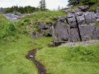
Below: A karst stream flows from a rock face, above ground - Click to enlarge
Assessing karst watercourses
Streams and watercourses are assessed during karst field assessments to determine if they sink or lose water to the subsurface. The assessment process also evaluates the significance of any recipient karst features receiving the water.
Sediment, organic material and woody debris can be transported downstream where it can accumulate and clog karst features. This can restrict water from entering the subsurface and/or redirect flows to other subsurface openings or to the surface. Another concern is the introduction of fine sediment and organic material into subsurface cavities and caves. These materials can coat underground surfaces, thereby impacting subsurface habitats and other cave resources or values. The slow decay rate associated with underground environments allows these materials to accumulate and persist over long periods of time.
Managing karst watercourses
This lesson will concentrate on the management of sinking/losing streams and sinking watercourses. But before moving on, you should understand how “stream” is defined, and how this definition relates to karst watercourses.
What is a stream?
Since 1995, the British Columbia government has defined a “stream” as a watercourse with a continuous channel of more than 100 metres in length that exhibits evidence of scouring or alluvial deposition.
Are all karst water systems streams?
While this definition can be applied to many of the surface streams flowing on karst terrain, some important watercourses that sink into the subsurface have the potential to be interpreted as non-classified drainages because they do not meet all the requirements of the definition for a stream. For example, stream segments that fail to meet the 100-metre distance criteria. However, even though these types of watercourses do not meet the definition for a stream, they should still be recognized and managed appropriately in cases where they flow into significant recipient karst features. To account for this situation, and to avoid confusion with the accepted definition for a stream, watercourses of this type are referred to as “sinking watercourses.”
Sinking and losing streams
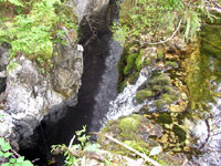
What is a sinking stream? Sinking streams are streams that disappear underground at a distinct sink point (that is, swallet).
What is a losing stream? Losing streams are streams that gradually lose water through an unconsolidated alluvial channel bed, or through a series of indistinct small openings, fractures or sink points.
*Important Note* --> For the purpose of the Karst Management Handbook for British Columbia, losing streams will only include those streams that lose water through small openings, fractures or sink points, since the transfer of sediment and debris to the subsurface through water loss associated with unconsolidated alluvial channel beds is likely to be negligible.
An important characteristic of some sinking and losing streams
Some sinking and losing streams can spend a large part of the year as a dry stream channel, only flowing when the subsurface karst system backs up and overflows during major storms or runoff events. When these types of streams flow, they can contribute major sources of sediment, organic material and other debris that are readily transported underground. On non-karst terrain, dry channels are generally not considered a major management concern; however, on karst terrain, dry sinking or losing stream channels should be carefully considered for riparian management.
Management objectives
The following are the management objectives for sinking and losing streams. These objectives apply, irrespective of whether the channels carry perennial, ephemeral or intermittent flows.
- Maintain water quality and quantity
- Limit the introduction of sediment, fine organic material or woody debris into subsurface environments within the range of natural conditions
Recommended best management practices
Two key recommended best management practices for sinking and losing streams are:
- Ensure that reserves and/or management zones along sinking or losing streams completely encircle the recipient karst feature where the water flows underground
- Consider the level of activity in the contributing non-karst catchment area when managing for water quality and quantity for significant recipient karst features
What are the recommended best management practices for sinking and losing streams? There are a number of recommended best management practices for sinking and losing streams within cutblock boundaries. The following scenarios are classified according to the width of streams and whether or not the streams flow on karst or non-karst terrain.
*Important Note* --> Management recommendations for sinking and losing streams are based on stream width, which is considered an indicator of transport potential. Recommended minimum width thresholds are different for streams flowing on karst (1.0m) compared to those flowing over non-karst (1.5m). This is to account for the inherent sensitivity of karst to the transport of fine particulate matter into subsurface environments, and also considers the tendency of streams flowing over karst to incise into the soluble bedrock, creating somewhat deeper, narrower channels.
Management Scenario: No. 1
The following four scenarios (1-1, 1-2, 1-3, 1-4) refer to sinking and losing streams that are:
- Less than 1 metre wide flowing on karst
- Less than 1.5 metres wide flowing on non-karst
Each scenario is followed by the recommended best management practices within the cutblock.
Scenario 1-1
A sinking or losing stream contributes water to a significant recipient karst feature located within 250 metres downstream of a cutblock boundary. Click to enlarge
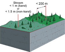
What are the recommended best management practices within the cutblock? The following practices are recommended within an appropriately sized riparian management zone:
- Retain windfirm trees with roots embedded in the bank
- Fall and yard away to the fullest extent possible
- Avoid cross-channel yarding
- Remove slash and debris that inadvertently enters the channel
- Retain windfirm non-merchantable trees and other windfirm vegetation (for example, understorey, shrubs, herbs) within 5 metres of the channel
- Retain windfirm wildlife trees
Scenario 1-2
A sinking or losing stream contributes water to a non-significant recipient karst feature located within 250 metres downstream of the cutblock boundary.
OR
A sinking or losing stream contributes water to a known significant recipient karst feature located more than 250 metres downstream of the cutblock boundary.
OR
A stream does not sink or lose water within 250 metres downstream of the cutblock boundary.
What is the recommended best management practice within the cutblock? Consult default standards for riparian management as specified in the regulations supporting the Forest and Range Practices Act.
Scenario 1-3
No stream assessment has been carried out.
What is the recommended best management practice within the cutblock? Assume the stream contributes water to a significant recipient karst feature located within 250 metres downstream of the cutblock boundary. Follow the same management recommendations as in Scenario 1-1.
Scenario 1-4
A stream assessment has been completed and a recipient feature was identified, but not assessed for significance.
What is the recommended best management practice within the cutblock? Assume the recipient karst feature is significant. Follow the same management recommendations as in Scenario 1-1.
Management Scenario: No. 2
The following five scenarios refer to sinking and losing streams that are:
- 1 to 3 metres wide flowing on karst
- 1.5 to 3 metres wide flowing on non-karst
- Each scenario is followed by the recommended best management practices within the cutblock
Scenario 2-1
A sinking or losing stream contributes water to a significant recipient karst feature located within 500 metres downstream of a cutblock boundary - click for larger image
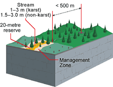
What is the recommended best management practice within the cutblock? Establish a minimum 20-metre reserve along the stream, with an adjacent management zone of an appropriate size to protect the reserve from windthrow.
*Important Note* --> Where there are fisheries or community watershed values associated with sinking or losing streams, consult default standards for riparian management as specified in the regulations supporting the Forest and Range Practices Act.
Scenario 2-2
A sinking or losing stream contributes water to a significant recipient karst feature known to be located more than 500 metres downstream of the cutblock boundary.
What are the recommended best management practices within the cutblock? The following practices are recommended within an appropriately sized riparian management zone:
- Retain windfirm trees with roots embedded in the bank
- Fall and yard away to the fullest extent possible
- Avoid cross-channel yarding
- Remove slash and debris that inadvertently enters the channel
- Retain windfirm non-merchantable trees and other windfirm vegetation (for example, understorey, shrubs, herbs) within 5 metres of the channel
- Retain windfirm wildlife trees
Scenario 2-3
A sinking or losing stream contributes water to a non-significant recipient karst feature located within 500 metres downstream of the cutblock boundary.
OR
A stream does not sink or lose water within 500 metres downstream of the cutblock boundary.
What is the recommended best management practice within the cutblock?
Consult default standards for riparian management as specified in the regulations supporting the Forest and Range Practices Act.
Scenario 2-4
No stream assessment has been carried out.
What is the recommended best management practice within the cutblock? Assume the stream contributes water to a significant recipient karst feature located within 500 metres downstream of the cutblock boundary. Establish a minimum 20-metre reserve along the stream, with an adjacent management zone of an appropriate size to protect the reserve from windthrow.
Scenario 2-5
A stream assessment has been completed and a recipient karst feature identified, but not assessed for significance.
What is the recommended best management practice within the cutblock? Assume the recipient karst feature is significant. Establish a minimum 20-metre reserve along the stream, with an adjacent management zone of an appropriate size to protect the reserve from windthrow.
Management Scenario: No. 3
The following four scenarios refer to sinking and losing streams that are:
- Larger than 3 metres wide flowing on karst or non-karst
- Each scenario is followed by the recommended best management practices within the cutblock
Scenario 3-1
A sinking or losing stream contributes water to a significant recipient karst feature located any distance downstream of the cutblock boundary - click to enlarge
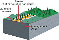
What is the recommended best management practice within the cutblock? Establish a minimum 20-metre reserve along the stream, with an adjacent management zone of an appropriate size to protect the reserve from windthrow.
Scenario 3-2
A sinking or losing stream contributes water to a non-significant recipient karst feature located any distance downstream of the cutblock boundary.
OR
The stream does not sink or lose water along its length.
What is the recommended best management practice within the cutblock? Consult default standards for riparian management as specified in the regulations supporting the Forest and Range Practices Act.
*Important Note* --> Where there are fisheries or community watershed values associated with sinking or losing streams, consult default standards for riparian management as specified in the regulations supporting the Forest and Range Practices Act.
Scenario 3-3
There has been no stream assessment.
What is the recommended best management practice within the cutblock? Assume the stream contributes water to a significant recipient karst feature located any distance downstream of the cutblock boundary. Establish a minimum 20-metre reserve along the stream, with an adjacent management zone of an appropriate size to protect the reserve from windthrow.
*Important Note* --> Where there are fisheries or community watershed values associated with sinking or losing streams, consult default standards for riparian management as specified in the regulations supporting the Forest and Range Practices Act.
Scenario 3-4
A stream assessment has been completed and a recipient karst feature identified, but not assessed for significance.
What is the recommended best management practice within the cutblock? Assume recipient karst feature is significant. Establish a minimum 20-metre reserve along the stream, with an adjacent management zone of an appropriate size to protect the reserve from windthrow.
Sinking watercourses
Definition of a sinking watercourse: To be considered a sinking watercourse, a watercourse must sink into the subsurface at a distinct sink point and possess one or more of the following characteristics:
- Poorly or non-defined channels (including flow over an organic bed)
- Exhibit no evidence of scouring or alluvial deposition
- Flow on the surface for less than 100 metres
As a minimum threshold, a sinking watercourse must follow a confined, linear drainage course with a distinguishable cross-sectional low point, accompanied by the presence of hydrophytic vegetation (plants that thrive in saturated soils).
Management objectives
Sinking watercourses are considered to be less of a management concern than sinking streams because of their lower potential for impacting significant recipient karst features. For example, sinking watercourses would typically exhibit low-energy water flows, lower transport potential, and intermittent or ephemeral flows. Nevertheless, sinking watercourses have the potential to transport sediment, fine organic material and small woody debris into the subsurface. For this reason, the management objectives for sinking watercourses are the same as those for sinking/losing streams.
Recommended best management practices
Where a significant recipient karst feature receives water from a sinking watercourse, the watercourse should be managed in a manner consistent with the management objectives for sinking and losing streams. The following best management practices are recommended within an appropriately sized riparian management zone:
- Retain windfirm trees with roots embedded in the watercourse edge
- Fall and yard away from the watercourse to the fullest extent possible
- Avoid yarding across the watercourse
- Remove slash and debris that inadvertently enters the watercourse
- Retain windfirm non-merchantable trees and other windfirm vegetation (understorey, shrubs, herbs) within 5 metres of the watercourse edge
- Retain windfirm wildlife trees
These recommended practices, or others deemed appropriate to achieve the management objectives, should be applied for a minimum of 100 metres upstream of the recipient feature, or to the point where the watercourse is no longer readily identifiable, whichever is shorter.
Important Note --> It is anticipated that in many cases, the reserve and management zone around a significant recipient karst feature will encompass much of the riparian management along sinking watercourses.
Self check questions
Answer either True or False to check your understanding.
- Riparian management on karst terrain focuses on sinking/losing streams and sinking watercourses
- Sinking watercourses do not meet the criteria for B.C.'s definition of a stream
- Maintaining water quality and quantity is one of the main management objectives for sinking/losing streams
- The management objectives for sinking watercourses are different from sinking/losing streams
- If a sinking/losing stream is less than 1 metre wide flowing on karst and delivers water to a significant recipient feature located less than 250 metres downstream, a 20-metre reserve is recommended
- Yarding across sinking watercourses is appropriate
Self check answers
- True
- True
- True
- False
- False
- False

