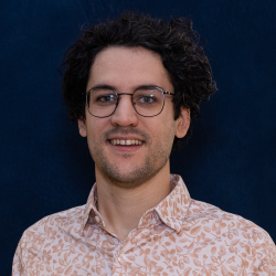
Easton Elia, B.Sc., P.Geo.
Quaternary Geologist
Easton is responsible for surficial geology mapping projects in British Columbia.
Education
University of Victoria (B.Sc., 2019)
Simon Fraser University (M.Sc., 2024)
Expertise
Easton joined the BCGS in 2019. He is a Quaternary geologist with experience in surficial mapping and drift prospecting in British Columbia’s Interior Plateau and north-central British Columbia. Easton briefly worked as a Geomatics Geoscientist in the BCGS Resource Information Section and was responsible for validating data and integrating geoscience maps to province-wide digital geology. Easton has expertise in collecting, processing, and interpreting multi-sensor remotely piloted aircraft systems (RPAS; or drone) data for surficial geology applications. In his current role, Easton is building a surficial geology compilation map and database for the Interior Plateau.
Publications
2024
Elia, E.A., Ferbey, T., and Ward, B.C., 2024. Mapping surficial sediments in the Interior Plateau using remotely piloted aircraft system lidar. British Columbia Ministry of Energy, Mines and Low Carbon Innovation, British Columbia Geological Survey Open File 2024-03, 12p.
Ferbey, T., Elia, E.A., Shives, R.B.K., Martin-Burtart, N., Best, M., and Ward, B.C., 2024. Quantifying potassium concentrations in Interior Plateau surface sediments using remotely piloted aircraft system gamma-ray spectrometry. British Columbia Ministry of Energy, Mines and Low Carbon Innovation, British Columbia Geological Survey Open File 2024-04, 19p.
Elia, E.A., Ferbey, T., Campagne, T., Best, M., Shives, R.B.K., and Ward, B.C. 2024. Investigating surface sediment composition in the Interior Plateau using a remotely piloted aircraft system magnetometer. British Columbia Ministry of Energy, Mines and Low Carbon Innovation, British Columbia Geological Survey Open File 2024-07, 15p.
Veness, H., Elia, E.A., and Ferbey, T., 2024. A digital update of Open File 1992-13: Surficial geology map index of British Columbia. British Columbia Ministry of Mining and Critical Minerals, British Columbia Geological Survey Open File 2024-09, 2 p.
Elia, E.A., 2024. Investigating subglacial till dispersal using remotely piloted aircraft systems. M.Sc. thesis, Simon Fraser University, Burnaby, British Columbia, Canada, 157 p.
2023
Elia, E.A., Ferbey, T., Ward, B.C., Shives, R.B.K., Best, M., and Martin-Burtart, N., 2023. Remotely piloted aircraft system (RPAS) for investigating surface sediments in the Interior Plateau of British Columbia: Methods, data, and products. British Columbia Ministry of Energy, Mines and Low Carbon Innovation, British Columbia Geological Survey GeoFile 2023-07, 22 p.
2021
Ferbey, T., and Elia, E.A., 2021. Preliminary surficial geology of the northern Hogem batholith area, north-central British Columbia. In: Geological Fieldwork 2020, British Columbia Ministry of Energy, Mines and Low Carbon Innovation, British Columbia Geological Survey Paper 2021-01, pp. 57-64.
2020
Elia, E.A., and Ferbey, T., 2020. Generating photogrammetric DEMs in the field from remotely piloted aircraft systems. In: Geological Fieldwork 2019, British Columbia Ministry of Energy, Mines and Petroleum Resources, British Columbia Geological Survey Paper 2020-01, pp. 189-200.

