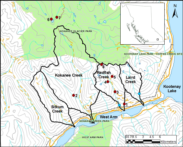
West Arm Demonstration Forest study area
The map below shows the watersheds and hydroclimate network under the West Arm Demonstration Forest program. Climate stations are shown in red and federally-operated hydrometric stations in blue. Climate station numbers correspond to those in the table.
The table below lists all of the active (current) and inactive climate stations of the WADF program. The numbers in the first column correspond to locations on the map above. Information is provided on the station elevation and the period of operation, as well as what meteorological variables (such as air temperature, relative humidity, etc.) are measured.
|
|
Climate Station |
Elevation (m ASL) |
Period of Record |
Variables |
|---|---|---|---|---|
|
1 |
Seedtree |
830 |
1992-present |
|
|
2 |
West Fork (Kokanee Creek basin) |
1200 |
1992-2011 |
|
|
3 |
Burn |
1290 |
1992-present |
|
|
4 |
Ross |
1615 |
1992-2011 |
|
|
5 |
Cabin |
1735 |
1992-present |
|
|
6 |
Kokanee (Keen Creek basin) |
1970 |
2004-present |
|
|
7 |
Ranger (Keen Creek basin) |
2020 |
1992-2006 |
|
|
8 |
Alpine |
2045 |
1992-present |
|
Contact information
Sarah Crookshanks
Research Geomorphologist, Kootenay Boundary Region
Sarah.Crookshanks@gov.bc.ca
Natasha Neumann
Research Hydrologist, Kootenay Boundary Region
Natasha.Neumann@gov.bc.ca

