Riparian management area guidebook
The Forest and Range Practices Act and its regulations took effect on Jan. 31, 2004. It replaced the Forest Practices Code of British Columbia Act and regulations. Forest Practices Code guidance is presented for information purposes only.
The guidance offered here is still relevant with regard to field practice.
Introduction
This guidebook is provided to help managers, planners, and field staff comply with the Forest Practices Code of British Columbia Act and to set and achieve the management objectives for riparian management areas (RMA) specified in operational plans. It provides guidance on planning and conducting operations within the RMA and fisheries- and marine-sensitive zones. It should be used in conjunction with other guidebooks such as those developed for forest development plans, biodiversity, managing identified wildlife, and range use.
Riparian areas occur next to the banks of streams, lakes, and wetlands and include both the area dominated by continuous high moisture content and the adjacent upland vegetation that exerts an influence on it. Riparian ecosystems contain many of the highest value non-timber resources in the natural forest. Streamside vegetation protects water quality and provides a "green zone" of vegetation that stabilizes streambanks, regulates stream temperatures, and provides a continual source of woody debris to the stream channel. The majority of fish food organisms come from overhanging vegetation and bordering trees while leaves and twigs that fall into streams are the primary nutrient source that drives aquatic ecosystems. Riparian areas frequently contain the highest number of plant and animals species found in forests, and provide critical habitats, home ranges, and travel corridors for wildlife. Biologically diverse, these areas maintain ecological linkages throughout the forest landscape, connecting hillsides to streams and upper headwaters to lower valley bottoms. There are no other landscape features within the natural forest that provide the natural linkages of riparian areas.
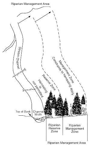
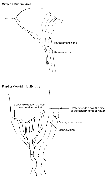
The RMA consists of a riparian management zone and, where required by regulation, a reserve zone (Figure 1). Within the management zone constraints to forest practices are applied. The width of these zones is determined by attributes of streams, wetlands or lakes, and adjacent terrestrial ecosystems. Inventory information as well as clarification of these guidelines may be obtained from the appropriate resource agencies.
Lakeshore management areas and wildlife habitat areas will frequently be associated with riparian management areas. In that situation, the guidebook that affords the greatest protection should be considered the authoritative document.
While marine-sensitive zones and fisheries-sensitive zones do not require classification they should be identified in operational plans. This document provides guidance on management strategies adjacent to these features.
This document applies to the entire province. Cases where a guideline is specific to either the coast or interior of British Columbia have been indicated.
RMA objectives
The identification, riparian classification, and mapping of streams, wetlands, and lakes and the description of appropriate practices is the responsibility of the proponent of the operational plan. This guidebook describes and refers to standard approaches and methodologies that can aid in developing prescriptions for riparian areas. In the absence of government approved permits and plans, the approaches and guidelines described here will be used by government to assess riparian classification, management, and mapping.
Riparian management area objectives are implemented:
- to minimize or prevent impacts of forest and range uses on stream channel dynamics, aquatic ecosystems, and water quality of all streams, lakes, and wetlands
- to minimize or prevent impacts of forest and range use on the diversity, productivity, and sustainability of wildlife habitat and vegetation adjacent to streams, lakes, and wetlands with reserve zones, or where high wildlife values are present
- to allow for forest and range use that is consistent with 1 and 2 above.
To achieve riparian management area objectives, forest practices within the management zone should:
Where a riparian management area has both a management zone and a reserve zone:
– reduce the risk of windthrow to the reserve zone
– retain important wildlife habitat attributes including wildlife trees, large trees, hiding and resting cover, nesting sites, structural diversity, coarse woody debris, and food sources characteristic of natural riparian ecosystems.
Where a riparian management area has only a management zone:
– retain sufficient vegetation along streams to provide shade, reduce bank microclimate changes, maintain natural channel and bank stability and, where specified, maintain important attributes for wildlife
– adjacent to wetlands and lakes, retain key wildlife habitat attributes characteristic of natural riparian ecosystems.
Streams
In the Operational Planning Regulation, a stream is a watercourse, having an alluvial sediment bed, formed when water flows on a perennial or intermittent basis between continual definable streambanks (see Figure 2). The key to identifying a stream is evidence of fluvial processes (sands, gravel, etc.) that have been deposited by moving water. Some smaller streams may have discontinuous streambanks, particularly in the interior, although the channel should be detectable throughout the extent of the stream reach being defined.
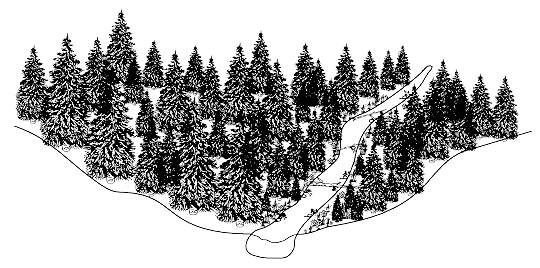
Some existing man-made channels, excluding ditchlines, that have significant fish and wildlife values may also require the same level of protection given natural watercourses. Consult with the B.C. Ministry of Forests, BC Environment and the Department of Fisheries and Oceans to confirm the value of these man-made channels.
Classifying streams
There are six stream riparian classes designated S1 to S6. Each stream reach receives a stream riparian classification based on:
- presence of fish
- occurrence in a community watershed
- average channel width.
A stream reach is a relatively homogeneous section of a stream having a sequence of repeating structural characteristics (or processes) and fish habitat types. The key physical factors used to determine reaches in the field are channel pattern, channel confinement, gradient, and streambed and bank materials. Stream reaches generally show uniformity in those characteristics and in discharge. The characteristics of stream reaches are described further in the Fish Stream Identification Guidebook.
A key to the riparian classification of streams is shown in Figure 3.
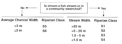
S1 to S4 streams are fish streams or streams in a community watershed. S5 and S6 streams are not fish streams and are not in a community watershed. The estuarine portion of a stream should be classified the same as the stream that has formed the estuary, as shown in Figure 4.
Determining fish streams
For the purposes of stream riparian classification, a fish stream means that portion of a stream that is either:
frequented by species of:
– anadromous salmonids
– rainbow trout, cutthroat trout, brown trout, bull trout, Dolly Varden char, lake trout, brook trout, kokanee, largemouth bass, smallmouth bass, mountain whitefish, lake whitefish, arctic grayling, burbot, white sturgeon, black crappie, yellow perch, walleye, or northern pike
– identified threatened or endangered fish
– regionally important fish as determined by the district manager and the Deputy Minister of the Ministry of Environment, Lands and Parks or a person authorized by the deputy minister, or
unless otherwise identified in a fish inventory acceptable to the district manager, as follows:
– before June 15, 1996 has a slope gradient of less than 20 per cent on the coast and 12 per cent in the interior and flows directly into:
~ a stream referred to in the above paragraph, "frequented species of:"
~ the Pacific Ocean
~ a lake known to support fish or
– on or after June 15, 1996 has a slope gradient of less than 20 per cent and flows directly into:
~ a stream referred to in the above paragraph, "frequented species of:"
~ the Pacific Ocean
~ a lake known to support fish.
Fish presence is confirmed by the occurrence of any life phase of each species, and includes:
- spawning and holding adults (e.g., anadromous salmonids enter freshwater from several months prior to just prior to the spawning season)
- incubating eggs
- overwintering and rearing juveniles and adults
- migrating juveniles and adults.
When stream classifications are assigned, documentation should be included that specifies whether classes are designated on the basis of either (a) an acceptable, existing fish inventory, (b) the completion of an acceptable fish inventory by the proponent, or (c) gradient criteria alone.
Approved stream inventory methods are outlined in the Fish Stream Identification Guidebook (Forest Practices Code). Supplementary information is available in the Stream Inventory Manual prepared by BC Environment, and the Stream Survey Field Guide produced jointly by BC Environment and the Department of Fisheries and Oceans.
Determining community watershed status
To determine whether a particular stream is within a community watershed and to locate watershed intakes, consult the Community Watershed Guidebook and contact the local BC Environment Regional Water Manager.
Determining average channel width
The average channel width for each stream reach partially determines the stream riparian class for that stream reach (along with fish presence and community watershed status). Once a stream is broken into reaches the following methodology can be applied to determine the average channel width for the reach. Once the average channel width has been determined, it can be used to classify the entire stream reach.
Stream channel widths vary depending on where in a watershed the channel is located. Generally, channels are relatively narrow in headwater areas and relatively wide downstream, near the mouth. The normal channel width can be greatly altered by both natural and man-induced factors. Channel width can be enlarged beyond the natural undisturbed channel width by debris torrents or flows, bank disturbances from logging operations, or by the removal of instream large woody debris (LWD).
Determination of stream riparian classes is based on normal, non-disturbed, channel widths. Be careful not to use a disturbed or unnaturally wide channel to determine the RMA. Further, recent debris torrents may cause oversized channels, resulting in a higher classification than is required.
Field indicators of channels recently affected by a debris torrent include:
- extensively eroded banks (over 80 per cent of both banks are eroded)
- complete loss of undercut banks
- extensive lengths of runs or riffles (channel consists of less than 20 per cent pool or deep water areas)
- expansive bars and relatively little flowing water (wetted width is less than about 20 per cent of the channel cross section)
- LWD levees lying along the channel margin
- minimal instream LWD
- woody debris incorporated in the sediment accumulations.
If the channel displays evidence of recent debris torrents the classification of the stream should be discussed with the appropriate resource agencies.
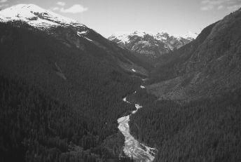
Figure 5. Debris torrented channel – photo of Landrick Creek, Haida Gwaii.
Undisturbed channels
Average channel width is often obvious enough to determine the respective stream riparian classification. Where the channel width is close to a stream riparian class break (i.e., 5 or 20 m) the following methodology should be employed.
Stream channel width is defined as the horizontal distance between the tops of the streambanks on opposite sides of the stream, measured at right angles to the general orientation of the banks (Figure 6). The top of the bank is usually indicated by a distinct change in vegetation and sediment texture. Above the top of the bank, the soils and terrestrial plants appear undisturbed by recent stream erosion. Bank areas below the top of the bank typically have freshly moved sediment (e.g., clean sands, gravels, and cobbles) and show signs of both sediment deposition and scouring.
Vegetated islands are not included. Where multiple channels are separated by one or more islands, the width is the sum of all separate channel widths.
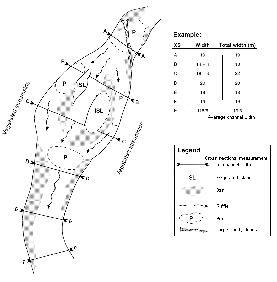
Unvegetated channel bars are included in the measured width.
The average width of the stream channel is calculated from six width measurements within a homogeneous reach. Each measurement should be spaced a distance approximately equal to the channel width from the previous one. This is accomplished by using the first measurement as a guide. For example, if the first stream channel width measurement is 16 m, the next five measurements should be spaced approximately 16 m apart (measured in a straight line down the centre of the channel), with the same alignment as the channel.
Additional stream modifiers
In addition to the six stream riparian classes there are several modifiers or conditions that do not affect classification but do influence the prescription for the stream riparian class.
Large rivers
There is a category of the S1 stream riparian class designated as a 'large river' that has, on average, over a 1 km length of a stream:
- an average channel width of 100 m or greater
- an active floodplain width (on one or both sides of the river combined) of 100 m or greater.
See the section "Large rivers and active floodplains," and Tables 6 and 7 (right) for information pertaining to large rivers.
Gullies
Another modifier of stream classes is the gully. Gullies are defined as follows:
- overall stream gradient is at least 25 per cent; and,
- a reach of the stream, greater than 100 m long that has:
- a sidewall greater than 3 m
- a side slope greater than 50 per cent
- a stream channel gradient greater than 20 per cent.
Streams in gullies, due to their steep gradients, are generally not fish streams. The Operational Planning Regulation requires that gullies on the coast be assessed using the Gully Assessment Procedure Guidebook. However, silviculture prescriptions and logging plans for gully management must not only address gully stability but also incorporate the wildlife provisions, pertinent to the stream class, outlined in Tables 5 through 13 in "Forest practices within the RMA, fisheries-sensitive zones, and marine-sensitive zones" of this document.
Watershed assessment procedure
A watershed assessment using the Interior Watershed Assessment Procedure (IWAP) and the Coastal Watershed Assessment Procedure (CWAP) may be required for community watersheds or watersheds with high fishery values (as determined by B.C. Forest Service and BC Environment). The results of these assessments may influence the best management practice within these RMAs. However, RMA objectives found in this guidebook should not be compromised. Consult the WAP guidebooks for the specific recommendations that apply.
Identifying large woody debris /root network dependent streams
The stability of some stream channels and streambanks is dependent on the continued presence of woody debris and live tree root networks in the channel and bank. The size of woody debris that functions in stream channels that help to maintain or create stream channel characteristics varies as a function of stream size. Logs or pieces of logs, in streams, larger than 0.5 m in diameter and greater than 1.5 m in length, are referred to as large woody debris (LWD).
LWD requirements for S1 to S3 streams are provided for by the reserve zone. Some S4 to S6 streams require the determination of the need for LWD and live tree root networks in the channel and bank.
Channels with the following features are generally dependent on LWD or live roots for channel and bank stability:
- lower gradient channels
- channels not controlled by boulders or bedrock
- unconfined channels with potential lateral movement
- channels controlled by pool riffle morphology.
Identifying temperature sensitive streams
Streams in relatively dry, warm climates may experience significant increases in water temperature following extensive removal of streamside vegetation. Increased temperatures can detrimentally affect the timing of fish development, result in mortality of aquatic organisms including fish, and decrease the quality of water for domestic consumption. These types of streams are considered to be temperature sensitive. Management strategies (see the section "Forest practices within the RMA, fisheries-sensitive zones, and marine-sensitive zones") have generally been developed to maintain overall stream shading for fish streams.
However, some streams may require further provisions in especially sensitive portions of the province. Streams where water temperatures are especially sensitive to vegetation removal occur primarily in the southern portions of British Columbia in the IDF, ICH, PP, BG, and CDF biogeoclimatic zones. Proponents should consult BC Environment and the Department of Fisheries and Oceans for specific information on local watersheds.
Streams that have low seasonal flows, wide/shallow channels, and minimum topographic shading from the south side are most sensitive to temperature change. Streams that have a large portion of the streamside vegetation removed should also be considered temperature sensitive.
Establishing stream RMA boundaries
The riparian management area adjacent to streams extends from the top of the streambank to the greater of:
- a slope distance as specified in Table 1, or
- the top of the inner gorge, or
- the outer edge of the active floodplain, or
- the outer edge of non-classified wetlands.
Specified slope distance
Table 1 (below) shows the specified slope distance of the respective reserve and management zone associated with each stream riparian class. In all cases, the reserve zone extends from the top of the streambank to the specified slope distance.
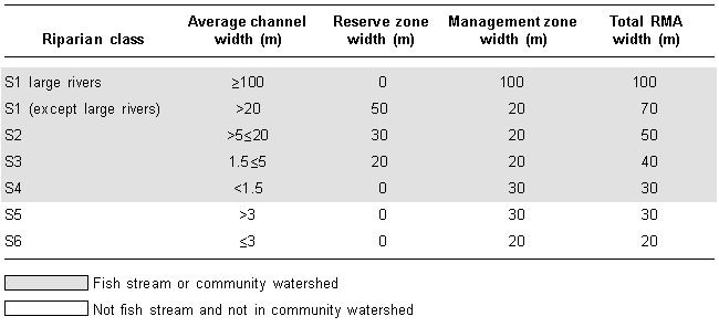
The management zone extends from the outer edge of the reserve zone, where one is present, or from the top of the streambank where no reserve zone is required.
Top of the inner gorge
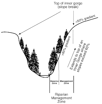
Where an inner gorge extends beyond the slope distances shown in Table 1, the RMA extends to the top of the inner gorge. An inner gorge is present where a stream is incised into a hillslope or valley bottom. Sidewall slopes are usually steeper than 60 per cent gradient. The top of the inner gorge occurs where the sidewall slope breaks to less than 50 per cent (Figure 7). Surface materials on the slopes of an inner gorge can be unstable and erodible.
Outer edge of the active floodplain
Where an active floodplain extends beyond the total RMA width shown in Table 1, the management zone of the RMA extends to the outer edge of the active floodplain. An active floodplain is any level area with alluvial soils, adjacent to streams, which is flooded by stream water on a periodic basis and is at the same elevation as areas showing evidence of:
- flood channels free of terrestrial vegetation
- rafted debris or fluvial sediments newly deposited on the surface of the forest floor or suspended on trees or vegetation
- recent scarring of trees by material moved by flood waters.
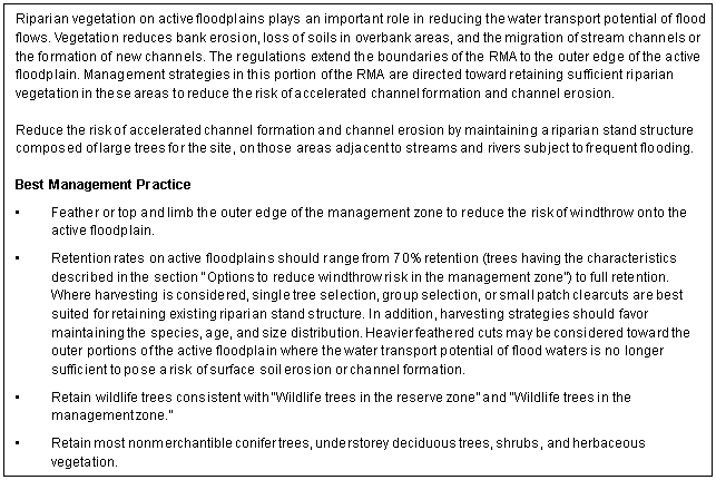
Riparian vegetation present in areas that are flooded plays an important role in reducing the water transport potential of flood flows. Vegetation reduces bank erosion, loss of soils in overbank areas, and the formation and migration of stream channels. Management strategies in this portion of the RMA are directed toward retaining sufficient riparian vegetation to meet these hydrological requirements.
The management of active floodplain (Figures 8, 9, and 10) provides larger trees for the site that will retain LWD/tree root networks to:
- maintain natural channel morphology
- reduce the potential for accelerated channel migration
- stabilize newly formed channels.
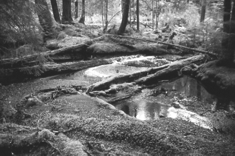
Figure 8. Example of active floodplain adjacent to a coastal stream. The channel is a flood channel 30 m from the present location of the main channel.

Figure 9: Example of active floodplain on the Squamish River. Active floodplains are flooded every 1–5 years on average.
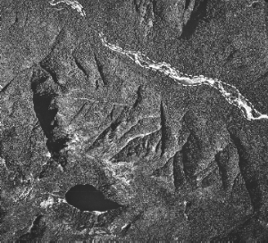
Figure 10. Air photo of active floodplain delineation along the Tahsish River.
The active floodplain is typically flooded every few years and may be less extensive than a broader floodplain that is bounded by a distinct terrace or slope break. The outer boundary of the active floodplain should be determined from field surveys. In cases where the outer edge of the active floodplain is unclear, contact the appropriate resource agencies for advice.
Non-classified wetlands and lakes contiguous to the RMA
The outer edge of wetlands and lakes that are too small to be classified and are contiguous to the RMA can be determined from on-the-ground surveys using the criteria outlined in the section "Determining the wetland area." These should be included in the stream RMA since they are often within the wetted portion of the stream during periods of high flow and often contain flood channels and pools that are important habitat for fish and other aquatic organisms. It is important to remember that the reserve zone width is determined from the top of the streambank, and that the management zone encompasses these non-classified wetlands or lakes as illustrated in Figure 11.
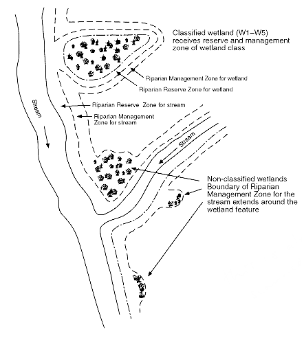
Classified wetlands or lakes contained within a stream RMA receive their own RMA according to their wetland or lake riparian class.
Wetlands
A wetland is a swamp, marsh, or other similar area that supports natural vegetation that is distinct from the adjacent upland areas. More specifically, a wetland is an area where a water table is at, near, or above the surface or where soils are water-saturated for a sufficient length of time that excess water and resulting low oxygen levels are principal determinants of vegetation and soil development.
Wetlands must have both:
- hydrophytic vegetation, characterized by the predominance of plant species that normally grow in standing water or in soils that are water-saturated for all or a major portion of their growing season
- subhydric or hydric soils, distinguished by free water or prolonged saturation, evidenced by dull gray gleyed horizons, within 30 cm of the mineral surface or by sedge or moss peat over mineral soils.
To be considered hydrophytic, the vegetation should include shrub or herbaceous species that occur only on organic soils or soils that are water-saturated for a major portion of the growing season. These species should make up 20 per cent or more of the combined cover of low (<2 m) shrub and herbaceous vegetation. Most (>80 per cent) of the remaining vegetation should be species that are able to establish and grow on water-saturated soils, even though they may not be restricted to these soils. Wetlands may or may not be treed, but when trees are present, the canopy is generally relatively open (<15 per cent canopy closure of trees >12.5 cm DBH), growth rates are much reduced compared to those on the surrounding better drained uplands, and the soil surface is usually hummocky. Wetlands may have up to 2 m of standing water.
Wetlands include shallow open water, swamps, marshes, fens, and bogs (see Appendix 1). In addition, shrub-carrs are included here as wetlands due to their close similarity to and association with wetlands. Shrub-carrs occur primarily in broad depressions and low-lying areas where forest development is limited by cold, periodically saturated soils. The water table is usually well below 30 cm during most of the growing season and the soils are usually not saturated for a sufficiently long period of time to show signs of saturation within 30 cm of the surface. Shrub-carrs are characterized by shrub-dominated vegetation (primarily scrub birch and willows) up to 2 m tall, often with widely scattered, taller trees. They do not include shrub-dominated sites from which a forest canopy has been removed by harvesting, wildfire, or other disturbances or shrub-dominated seepage slopes, such as Sitka alder slopes in the interior, which do not meet the above definition of wetlands.
Classifying wetlands
There are five riparian classes of wetlands (W1 to W5) based on:
- whether the wetland is a simple wetland or wetland complex
- wetland size
- biogeoclimatic unit in which the wetland occurs.
W1 to W4 wetlands are simple wetlands while W5 is a wetland complex. A key to riparian classification of wetlands is illustrated in Figure 12.
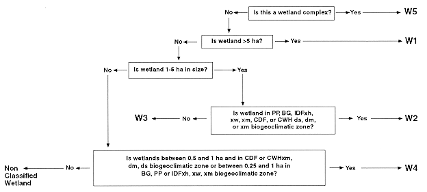
Determining simple wetlands and wetland complexes
Simple wetlands include all classified wetlands that are not wetland complexes.
A wetland complex consists of two or more individual wetlands with overlapping riparian management areas and a combined wetland area of 5 ha or more. Two wetlands have overlapping riparian management areas if they are:
- separated by 60 m or less and both are <5 ha, or
- separated by 80 m or less if one is <5 ha and the other is >5 ha, or
- separated by 100 m or less if both are >5 ha.
The individual wetlands of a wetland complex should be sufficiently large that they would otherwise be classed as W1, W2, W3, or W4. Wetland complexes have a riparian class of W5.
Wetland complexes (see Figure 13) are areas of wetland and upland terrain where wildlife and biodiversity values of RMAs adjacent to individual wetlands are enhanced due to the close proximity to other wetlands. The RMA separating two or more closely associated wetlands provides a frequent travel corridor between the individual wetlands and links them into a larger wetland habitat unit. Forest practices adjacent to these wetlands are especially challenging due to their complexity and value. To address this challenge, some flexibility has been designed into the management practices adjacent to wetland complexes as outlined in "Modifying the RMA."
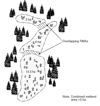
Determining the wetland area
Since the outer edge of wetlands is often treed, it may not be possible to determine the wetland boundary, and thus wetland area, directly from forest inventory maps. Wetland boundary can be interpreted from 1:20 000 or larger scale stereoscopic aerial photographs or determined by on-the-ground surveys.
The outer boundary of a wetland can be closely approximated from 1:20 000 or larger scale aerial photographs, by noting where:
- forest canopy (trees >12.5 cm DBH) closure is greater than 15 per cent or not distinguishable from that characteristic of the better drained uplands
- evidence of wetland processes, such as channels and surface water pools, and wetland vegetation are not present beneath the tree canopy.
The wetland boundary can be determined from on-the-ground surveys by mapping the upslope extent of the following combination of conditions:
- Predominance of plant species that normally grow in water or water-saturated soils or in peat soils (plant communities that indicate subhydric or hydric ecological moisture regime)
- Soils that are water-saturated or show evidence of prolonged water saturation (gleying) within 30 cm of the surface or are peat soils
- For shrub-carrs, the transition between shrub dominated and tree dominated vegetation.
Determining the biogeoclimatic unit
Biogeoclimatic unit (zone, subzone, and variant) can be determined from biogeoclimatic maps and biogeoclimatic ecosystem classification field guides prepared by the Ministry of Forests, Research Branch.
Additional wetland modifiers
In addition to the five wetland riparian classes there is a modifier to large W1 and W5 wetlands that does affect the application of the RMA.
Large bogs and muskeg dominated wetlands
These wetlands are a category of very large ( >1000 ha) W1 and W5 wetlands in which the landscape is dominated by (>50 per cent) sphagnum wetlands (bogs including muskeg terrain). They occur in the boreal, parts of the sub-boreal, and hypermaritime climates. In these circumstances, wetlands are not restricted to depressions and the toe of slopes, but can occur on raised areas and sideslopes as well. There is no reserve or management zone required around the outer perimeter of these wetlands. However, where wildlife values or biodiversity concerns warrant, a reserve or management zone may be established by the district manager on patches of upland forest within these wetlands.
Large wetlands adjacent to streams
Where large contiguous wetlands (>500 ha) occur as significant linear landscape features adjacent to streams, the district manager, with the agreement of a designated environment official, may exempt the requirement for a riparian reserve around the outer edge of the wetland.
Establishing wetland RMA boundaries
Table 2 shows the specified slope distance of the reserve zone and management zone of each wetland RMA class.
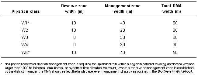
Table 2. Specified minimum slope distances for wetland riparian management areas
* No riparian reserve or riparian management zone is required for upland terrain within a bog dominated or muskeg dominated wetland larger than 1000 ha in boreal, sub-boreal, or hypermaritime climates. However, where a reserve or management zone is established by the district manager, the RMA should reflect the landscape level management strategy as outlined in the Biodiversity Guidebook.
Simple wetlands
In all cases the reserve zone extends from the outer edge of the wetland to the slope distance specified in Table 2 as shown in Figure 14. The management zone extends from the outer edge of the reserve zone or the outer edge of the wetland, where no reserve zone is required, to the specified slope distance.

Figure 14. Riparian management area adjacent to a simple wetland.
Wetland complexes
The outer RMA boundary of the reserve zone and management zone around wetland complexes is determined by the slope distances in Table 2 measured from the outer edge of each of the outermost wetlands of the complex (Figure 15).
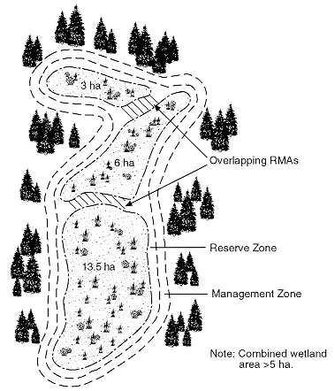
Figure 15. Determining the RMA of wetland complexes.
W1 and W5 bog and muskeg dominated wetlands
Where a reserve or management zone is established by the district manager, the RMA should reflect the landscape level management strategy as outlined in the Biodiversity Guidebook.
Lakes
Classifying lakes
There are four riparian classes of lakes (L1 to L4) as determined by:
- lake size
- biogeoclimatic unit in which they occur.
The proponent is responsible to determine the riparian class of all lakes. Figure 16 provides a key to determine the lake riparian classification.
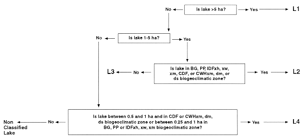
Determining lake area
Lake area can be determined directly from 1:20 000 or larger scale aerial photos or maps. The outer edge of a lake can be determined in the field by the normal high-water mark.
Determining the biogeoclimatic unit
Biogeoclimatic unit (zone, subzone, and variant) can be determined from biogeoclimatic maps and biogeoclimatic ecosystem classification field guides prepared by the Ministry of Forests, Research Branch.
Additional lake modifiers
In addition to the four lake riparian classes there are two modifiers that affect the application of the RMA.
- L1 lakes less than 1000 ha
- L1 lake riparian class (lakes >5 ha) have an additional lakeshore management zone (LMZ) that is established by the district manager adjacent to the riparian reserve zone. Proponents should consult their Regional Lake Classification Guidebook for lakeshore management zone guidelines.
L1 lakes greater than 1000 ha
These lakes are a category of L1 lakes that are greater than 1000 ha. There is no riparian reserve or riparian management zone required for these L1 lakes. However, the LMZ prescription should accommodate fisheries and wildlife values or biodiversity concerns. LMZ guidelines should be designed to maintain a wide variety of values including fish, wildlife, recreation, and water.
Establishing lake RMA boundaries
Table 3 shows the specified slope distance of the respective reserve zone and management zone of each lake riparian class. The outer edge of the lake is measured from the high-water mark or the edge of an immediately contiguous wetland.

Modifying the RMA
The Operational Planning Regulation makes provisions for varying the width of the riparian reserve zone or management zone. Proposals to vary the width of a reserve zone should be supported by sufficient information to justify the decision and to allow resource agencies to properly evaluate the proposals.
Supporting documentation should clearly identify the rationale for the proposal and describe the measures that will be taken to ensure that the riparian objectives stated in "RMA objectives" of this guidebook are addressed. It should provide sufficient information to justify the proposal over other reasonable options and allow an adequate assessment of the anticipated impacts to aquatic and terrestrial habitats adjacent to the proposed development and in downstream or surrounding areas.
Suggested supporting information
The scope and detail of information provided should be in proportion to the magnitude of the proposed removal or modification. For example, topping and limbing or removal of a very small number of trees from the reserve zone may require only a brief description.
The following information should be provided where appropriate to support the proposal:
- rationale
- logging plan
- riparian classification and proposed widths of reserve and management zones
- ecological characteristics of the RMA and attributes that may be affected (ecosystem, stand structure, age class and leading species, fish and wildlife habitat values, coarse woody debris amounts and sizes)
- silvicultural system and removal level
- details of road building including a deactivation plan
- outline of risk assessments (e.g., windthrow, riparian habitat loss, road failure)
- measures to meet riparian management objectives
- assessment of anticipated impact of the proposed forest practice on the contiguous riparian ecosystem
- measures to maintain bank and channel stability and prevent sedimentation
- per cent of the stream RMA previously harvested without buffers.
Large rivers and active floodplains
Adequate planning adjacent to large rivers and active floodplains may require the production of a longer-term forest development plan as provided in the Operational Planning Regulation. The following information should be provided when proposing activities adjacent to large rivers and on any active floodplain:
- all of the information from "Suggested supporting information" above
- percentage of the floodplain within the forest development plan area previously harvested and proposed for harvesting within the period of the forest development plan
- assessment of the lateral stability of the channel.
Wetland complex
Adequate planning adjacent to or within wetland complexes may require the production of a longer-term forest development plan as provided in the Operational Planning Regulation. The following information should be provided when proposing activities adjacent to or within wetland complexes:
- the first nine points from "Suggested supporting information" above
- percentage of the upland area within the wetland complex previously harvested and proposed for harvesting within the period of the forest development plan
- ecological characteristics of the wetland complex (principal ecosystems of the uplands and wetlands; distribution of forest age classes and leading species; principal hydrological attributes of the wetlands such as presence of standing water, presence of lakes and streams, and flow between wetlands; fish and wildlife resource values, or other values).
Forest practices within the RMA, fisheries-sensitive zones, and marine-sensitive zones
This section provides recommendations regarding silviculture, harvesting, and road construction practices within the RMA. Range use guidelines are contained in the section "Range in riparian areas."
These recommended forest practices were developed with consideration given to their potential impact on timber supply. Given the high degree of variability in site conditions within riparian management areas, it is not possible to provide a single prescription suitable for universal application. Site-specific decisions must be made regarding the appropriate level of retention within riparian management zones and the types of trees to be retained. Such factors as topography and windthrow hazard will determine the best management practice on a site specific basis. In addition, on each site where a level of tree retention is prescribed, the forest management practice specified for the portion of the management zone not occupied by retained trees must be adequate to ensure that these areas are fully productivity. This is required to ensure there are no unaccounted timber supply impacts attributable to the implementation of these riparian management recommendations.
The following table summarizes the maximum overall levels of retention within the riparian management zones for each riparian class of stream, wetland and lake that are anticipated to result from consistent implementation of the best management practices recommended in this guidebook. The maximum overall levels of retention represent the average levels of retention for all of the reparian management zones for each reparian class of stream, wetland and lake that occur within the cutblocks identified in a forest development plan.
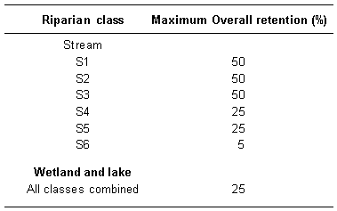
Table 4. Maximum overall average levels of basal area retention within the riparian management zone for each riparian class of stream, wetland, and lake. Acceptable overall average levels of basal area retention within the riparian management zone for each riparian class of stream, wetland, and lake (overall average is calculated as the average for all cutblocks within a forest development plan).
These overall retention levels are not intended to be applied on a cutblock by cutblock basis and should not be interpreted as being the required or target level of retention for every riparian management zone. Site-specific application of the range of best management practices should ensure that the overall retention within a forest development plan area does not exceed the maximum levels specified. In some circumstances, e.g. forest development plan areas dominated by high windthrow hazards, the overall level of retention may be lower than that specified in the table.
The following section applies to all riparian areas plus FSZ and MSZ and are to be viewed as 'Best Management Practices' to guide development of prescriptions for the RMA of each riparian class.
General guidelines
Riparian features may be encountered in the field that have not been identified in the silvicultural prescription or logging plan. In such circumstances, forest harvesting adjacent to the stream, wetland or lake should cease until the appropriate feature is classified and the practice is implemented. For audit purposes and where appropriate, changes should be reflected in an amended silvicultural prescription/logging plan. If environmental damage has occurred, the appropriate government agency should be contacted.
Activities within streams and wetlands
Streams, wetlands, and lakes should not be entered. Instream activities on fish streams, or on stream reaches that could affect fish habitat, or on stream reaches that could affect fish habitat or water quality downstream, may only be undertaken when constraints relative to fish life history or expected streamflows allow. Refer to Appendix 2 for general windows for instream work by regional area and species.
Keep in mind that instream work windows provide a general guide only and do not relieve the proponent of the responsibility to contact local fisheries agencies for information on site-specific mitigation requirements. In addition, although a work period for a particular instream activity may be identified and approved, the proponent should still ensure that the actual work is carried out in a manner that avoids the destruction of fish habitat.
In addition to classified streams, wetlands, and lakes, there are wet depressions or receiving sites that are not classified. The tracks and wheels of ground-based equipment should not be operated within 5 m of any stream, wetland, or lake feature whether classified or not.
Roads and crossings
Roads within an RMA that are parallel to a stream, wetland, or lake should be designed to minimize short- and long-term impacts on the RMA. This can be done by methods such as minimizing road bed width, minimizing right-of-way width, end-hauling, full bench construction, constructing temporary roads, and deactivating roads after harvesting is completed. Temporary and permanent stream crossings should not damage fish habitat or create blockages to fish passage. This includes small channels that provide access to fisheries-sensitive zones. Temporary stream crossing methods should include crossing streams at right angles and the use of box culverts to avoid damage to streambanks. Temporary crossing sites should have stable banks and avoid instream, stable LWD. Remove all temporary structures once operations are completed. When streambank disturbance is evident and erosion is likely to occur, bank armouring and streamside vegetation must be re-established.
Existing main roads within the RMA can continue to be used. Spur roads within the RMA should be permanently deactivated once they are no longer used.
Streams and side channels should not be artificially channeled to reduce the number of culverts required. Each channel should be adequately culverted. Extra and oversized culverts should be installed where roads cross the active floodplain. In addition, fill heights should be minimized within the active floodplain and the fill protected from erosion. Avoid fill construction on floodplains that parallel the stream.
Falling and yarding
Falling and yarding should be away from, or parallel to, a stream, wetland, or lake. Cross-stream yarding occurs when a log or portion of a log is yarded over a stream and contacts any part of the bank, channel, or vegetation in the RMA. It is distinguished from full suspension yarding. Cross-stream yarding should normally be undertaken only on S5 and S6 streams following the prescriptions in this guidebook and the Gully Assessment Procedure Guidebook, where streambanks are stable, and where natural LWD in the channel will not be destabilized by the falling and yarding process.
Construction and location of full suspension yarding corridors should minimize removal or modification of trees, especially wildlife trees. Long line yarding cables can significantly damage wildlife trees by knocking off branches and tops of these trees. Long line yarding through RMAs should only occur during periods of low flow or over thick ice to allow removal of debris.
Where falling away from the channel cannot be achieved and the remaining stems threaten channel stability due to windthrow, consider falling across the stream only if the stem will span the stream and can be lifted without damaging streambanks and non-merchantable stems or disturbing stable LWD. Where this cannot be done, address windthrow management according to the section "Windthrow hazard management." When yarding will damage non-merchantable stems, streambanks, or stable LWD, leave that section of stem spanning the channel, providing it is stable and does not obstruct streamflow or fish passage.
When the channel has the capability to transport debris, reduce the impact of logging debris entering the channel from logging operations, including either cross-stream or full suspension yarding, by:
- falling away from the channel and using yarding methods that minimize breakage and debris entry into the channel
- conducting logging operations during periods of low flow
- cleaning out all unstable debris from the channel in accordance with guidelines in the section "Stream clean-out."
Uphill falling
Uphill falling can be hazardous to workers and should be avoided. For all stream riparian classes other than S6, where uphill falling is hazardous, trees in question should be left. For S6 streams:
- Fall across the channel without damaging instream LWD and unstable streambanks.
- Remove the tree only if it can be lifted clear of the channel without damaging the banks or stable LWD.
- If this cannot be done, leave the portion of the stem spanning the channel, and clean out the stream according to "Stream clean-out" below.
Stream clean-out
Where stream clean-out is required it should be carefully supervised to ensure only unstable debris is removed and placed above the high-water level. Removal of stable debris (i.e., debris that is embedded in the channel or is impounding channel bedload) is detrimental to channel stability. The following additional considerations should guide stream clean-out operations:
- Refer to the Gully Assessment Procedure Guidebook for detailed prescriptions on gully clean-out.
- Do not use heavy machinery where stable, instream LWD or streambanks will be disturbed.
- Hand clean when necessary to protect stable LWD or to complete the removal of fine debris following machine clean-out. Use aerial methods, such as helicopter yarding, to remove debris from confined streams such as gullies.
- Conduct stream clean-out concurrently with logging to reduce the chance that introduced debris will be subjected to high stream flows. Inspect cleaned streams following the first freshet after logging. Conduct further clean-out where necessary.
- Place removed debris to ensure it does not re-enter the stream.
- Stream channel cleaning should be done from upstream to downstream.
- Use debris traps or 'grizzlies' to manage downstream movement of debris only where the channel to be managed consists of bedrock or boulders. Debris traps should be located on a stable site with machine access to permit cleaning of the trap. Suggestions for design and installation of debris traps are available in "A Guide for Management of Landslide-Prone Terrain in the Pacific Northwest," ISSN 0229-1622, 1994.
Fisheries-sensitive zones
Fisheries-sensitive zones (FSZs) are side and back channels, ponds, swamps, seasonally flooded depressions, lake littoral zones, and estuaries that are seasonally occupied by over-wintering fish. Fisheries-sensitive zones should be identified and protected by the proponent during forest harvesting operations as follows:
- Flag the FSZ and maintain a 5-m machine exclusion zone.
- Retain nonmerchantible conifer trees, understorey deciduous trees, shrubs, and herbaceous vegetation within 5 m of the FSZ to the fullest extent practicable.
- Fall and yard away from FSZs.
- Do not introduce sediment and debris into FSZs.
- Do not restrict natural water patterns associated with FSZs.
- Avoid road construction through FSZs.
- Time operations so as to minimize effects on FSZs.
- Do not restrict fish passage to or from FSZs.
Marine-sensitive zones
Marine-sensitive zones (MSZs) include herring spawning areas, shellfish beds, marsh areas, existing aquaculture sites, juvenile salmonid rearing areas, and adult salmon holding areas.
Coastal log handling and upland forest harvest operations can damage MSZs. This occurs through:
- direct damage from operation of heavy equipment
- infilling
- introduction of debris into marine environment
- increased silt load to the environment.
MSZs should be protected during forest harvesting operations as follows:
Any forest harvesting activities adjacent to MSZs should be carried out to avoid significant negative impacts. Where a MSZ is identified, it should be treated as a downstream value for developing the management prescriptions from streams discharging into the MSZ.
All floating debris entering the marine environment from log dumping operations, A-frame or handlogging operations, helicopter, or balloon drop area operations should be disposed of in a manner so that it does not re-enter or contaminate the aquatic environment by:
– minimizing the introduction of logging debris to the marine environment by such methods as removing limbs and tops before yarding and avoiding long flight paths over water bodies
– containing debris entering the marine environment from A-frame, hand logging, or helicopter/balloon drop area operations by use of perimeter booms
– conducting periodic sweeps of the water surface to capture floating debris before it sinks.
Windthrow hazard management
Riparian management areas in stands of moderate or high windthrow hazard require special management practices to reduce windthrow potential when logging is proposed within and adjacent to them. Where a reserve zone is required, windthrow hazard management should be designed primarily to protect the reserve zone and only secondarily to protect trees within the management zone.
Assessing windthrow risk
The Windthrow Handbook for British Columbia Forests (Research Program Working Paper 9401) should be consulted for guidance when assessing windthrow risk or developing prescriptions to reduce the risk of windthrow. Windthrow risk assessments should incorporate local knowledge and experience and should be assessed for the general area and, in greater detail, for each area with significantly different soil depth or drainage, stand structure, and tree species composition. Windthrow risk assessment should be a best judgment interpretation based on an evaluation of regional, local, and site-specific available information.
Windthrow risk is determined by the interaction between factors that affect the force of the wind acting on the tree and factors that affect the resistance of the tree to overturning. Force of the wind is increased by higher wind velocity and turbulence, increased exposure to wind, greater tree height-to-diameter ratio, greater crown size and crown density, and reduced stand density. Resistance to overturning is reduced by poor root anchorage due to saturated soils and restricted rooting depth, occurrence of root or bole rot, extent of interlocking root systems, and past exposure to winds. Soil factors that control rooting depth contribute most significantly to windthrow risk.
High risk stands generally occur where high wind force is likely to occur and resistance to overturning is low. Moderate risk stands occur where root anchorage is poor but wind force is low, root anchorage and wind force is moderate, or root anchorage is good but wind force is likely high. Low risk stands occur where there is a high resistance to overturning and wind force is moderate or low.
Windthrow risk is generally greatest on the windward edge of a stand and decreases a short distance into the stand, although turbulence can result in windthrow several tree heights into the stand. Most windthrow occurs within the first three years following harvesting. However, windthrow risk can increase over time as management activities affect windflow and soil conditions.
Local knowledge is an important consideration when assessing windthrow risk. Certain areas are known to be particularly windy. A history of frequent windthrow and evidence of windthrow or stem breakage in natural stands is an indication that windthrow is likely to occur after harvesting.
Windthrow management strategies
Strategies to reduce the risk of windthrow should be considered wherever trees are retained and windthrow risk is moderate or high along all or a portion of the RMA. Windthrow management strategies include locating the tree retention boundary to reduce the risk of windthrow, selecting the most windthrow resistant trees within the management zone for retention, and reducing the force of the wind on the crowns of retained trees. Selected strategies should not only address windthrow risk but also the other values that are being protected in the RMA.
Options to reduce windthrow risk to reserve zone
Where windthrow risk is moderate or high in the reserve zone, a sufficient number of trees should be retained within the management zone to protect the windfirmness of the reserve zone. Options include:
location and design of logging boundaries:
– realign RMA boundary to a windfirm edge such as rock bluffs, non-merchantable timber, or soil type change
– leave a buffer at least 20 m wide of well-drained, deep soils between areas of poorly drained or shallow soils of the RMA and the edge of the harvested opening
– where no natural windfirm features are available, consider widening the management zone to a moderate to low windthrow risk stand and align the boundary so that it is at an angle or parallel to the prevailing storm winds
– leave relatively straight boundaries on the outer edge of the RMA; this can be accomplished adjacent to meandering streams by leaving variable width patches of trees in the management zone; do not leave any sharp corners or indentations that are exposed to the wind
– where the management zone is more prone to windthrow than the reserve zone, low tree retention in the management zone may be the most appropriate option.
edge stabilization treatments:
– feather the outer edge of the management zone by removing trees prone to windthrow; preference should be given to removing the following trees:
~ unsound trees including diseased, deformed, forked, scarred, mistletoe infested, and root rot infested trees; trees with asymmetric or stilt roots; trees growing on unstable substrates such as rocky knolls, large boulders, nurse logs, or wet depressions; tall non-veteran trees, especially those with disproportionately large crowns
Preference for retention should be given to sound, well-rooted veterans (e.g., snag-top cedars) or deciduous trees; sound trees (strong roots and good taper) with relatively small, open crowns; and sound snags when safety is not compromised.
In multi-storied stands, the outer wind-exposed edge of the management zone may be additionally feathered by removing dominant trees from the leading edge, partially retaining codominant trees, and fully retaining suppressed trees within 20–30 m of the edge. This practice is not recommended in single-storied, high density stands.
– top and/or prune (limb) individual trees with a high windthrow risk in the management zone and/or reserve zone; reduce the crown of these trees by 20–30 per cent; topping or pruning in the reserve zones should include only high windthrow risk trees that may cause significant detrimental effects to stream channels or wildlife habitat if they were windthrown;
– combine edge feathering and topping or pruning in high hazard areas.
Options to reduce windthrow risk in the management zone
Options to reduce the risk of windthrow to trees retained in the management zone include topping or pruning (see above) and selection of the most windfirm trees for retention. Trees with the following characteristics tend to be the most windfirm:
- small, open crowns
- good root anchorage in deep, well-drained soils
- no root or bole rot
- low height-to-diameter ratio for stand (relatively large taper)
- short trees
- trees that have been growing in relatively open stands
- broad-leafed deciduous species
- specific conifer species
- sound snags
- sound, well-rooted veteran trees.
Removal of windthrown trees
When windthrow occurs within a RMA, the remaining standing trees should be left as a protective buffer for other trees of the RMA. Windthrown trees should not be removed from the RMA, as they provide valuable wildlife habitat. Windthrown trees should be removed only if habitat would be improved by their removal and removal will not result in damage to the surviving trees. Windthrown trees should be assessed for removal by a forest health specialist where there is a risk of increasing bark beetle populations and the resultant increase in tree mortality. Windthrown trees that have entered a stream should be removed only if they will destabilize the streambank or channel. Unnecessary removal of windthrown trees from streams can result in significant channel destabilization. All removal of windthrown trees from an RMA must be as specified in an approved silviculture prescription or logging plan.
Wildlife tree management
A wildlife tree is a standing live or dead tree with special characteristics that provide valuable habitat for conservation or enhancement of wildlife (large diameter and height for site, current use, declining or dead, valuable species type, location, and relative scarcity). High quality wildlife trees are frequently present in riparian areas and are used by a variety of species. The proximity of these trees to the edge of streams, wetlands, lakes, and marine-sensitive zones increases their value for some wildlife species. Wildlife trees also provide a source of coarse woody debris used by many riparian species and large woody debris for maintaining stream channel characteristics.
The Biodiversity Guidebook and Managing Identified Wildlife Guidebook provide recommendations for the amount, type, and distribution of wildlife trees to be left within a cutblock and area adjacent to the perimeter of the cutblock. Although wildlife trees should be distributed across the planning area, riparian habitats are priority sites for meeting these recommendations. Not only are high quality wildlife trees present in many riparian areas, but the riparian management area also provides an opportunity for leaving wildlife trees with the least effect on timber harvesting operations.
Wildlife trees in the reserve zone
Reserve zones adjacent to streams, wetlands, and lakes protect many wildlife trees and provide a source of future wildlife trees. However, some wildlife trees within the reserve zone can pose a risk to workers operating in the management zone or the cutblock outside the RMA (see Figure 17). These include standing dead trees that are vertical or lean towards the management zone, as well as some live trees with large dead branches or tops. The best strategy for protecting these trees is for a qualified wildlife tree assessor to mark them as wildlife trees and establish no-work zones around them. The size of the no-work zone will vary by tree and site. Generally, the size of the no-work zone will be one or two tree lengths.
Not all wildlife trees in the reserve zone that pose a risk to workers in the management zone need to be protected by a no-work zone. If wildlife tree requirements have been met outside of the RMA and no eagle, osprey, or great blue heron nest trees or high value wildlife trees are present, wildlife trees deemed hazardous to worker safety within the reserve zone may not need to be protected. Mitigative measures should be taken to protect high value wildlife trees (consult the Wildlife/Danger Tree Assessor's Course Workbook).
When making a determination to remove a wildlife danger tree from a reserve zone, as provided for in the Operational Planning Regulation, a wildlife tree assessment should be completed by a qualified wildlife tree assessor. If a tree is determined to be unsafe and of low wildlife value it may be felled. Trees felled in the reserve zone should be left as coarse woody debris. Trees killed by bark beetles, where beetles remain under the bark, that pose a high risk to adjacent stands should be removed or treated to kill the bark beetles prior to emergence. Trees to be felled should be identified in an approved silviculture prescription and/or logging plan.
Wildlife trees in the management zone
All dead wildlife trees that do not pose a risk to workers should be left within the management zone adjacent to the reserve zone or adjacent to the stream, wetland, or lake where no reserve zone is required. Trees retained within the management zone should emphasize wildlife tree attributes. In addition, consider establishing wildlife trees within management zones to meet wildlife tree objectives described in the Biodiversity Guidebook. If harvesting is done by feller buncher, consider felling some wildlife trees at a height near 3 m to create "stubs."
Silviculture treatments
Forest harvesting within the management zone should minimize disturbance to understorey vegetation and avoid damage to remaining trees. Disturbance should be limited to that necessary to achieve successful regeneration.
The following guidelines outline recommendations for silvicultural treatments within the riparian management area:
- Carry out single-tree forest health treatments when damaging agents such as bark beetles threaten the integrity of the RMA or the forest adjacent to the RMA stands. Preferred strategies for managing bark beetles in the RMA include "Prevention, Suppression, and Maintain Low" strategies (see Bark Beetle Management Guidebook).
- Minimize the impact on the naturally occurring understorey vegetation within the management zone of streams, wetlands, and lakes.
- Maintain natural levels of coarse woody debris within the RMA.
- Address root diseases in the RMA through the use of alternative tree species or other options, rather than stump removal.
- Choose silvicultural strategies and equipment to minimize ground disturbance within the RMA.
- Conduct broadcast burning within the RMA only where no treed reserve exists unless specified in an approved silviculture prescription or burning permit.
Vegetation management
When selecting treatment options for vegetation management within the RMA, consider the potential impact of the treatment on all resources. The following measures are recommended for all vegetation management applications.
Where vegetation management is required to meet reforestation or restoration objectives, treatment within the RMA should be restricted to selective treatment of vegetation in direct competition with desirable trees.
Where approval is requested a) to carry out individual-tree treatment within the 10-m PFZ, or b) for aerial or ground spraying adjacent to S5 and S6 dry channels, or c) aerial spraying over S6 dry channels, a field review will generally be required. The following information will facilitate office review and help determine if a field inspection is needed:
– stream class
– proposed treatment method and herbicide
– distance to S1 to S4 stream reaches or a fish bearing lake
– bank depth; channel width; gradient; months of the year channel is wetted
– composition of bank material (e.g., sand, gravel, boulders)
– bank vegetation community (list species, average height, and percentage of target and non-target susceptible vegetation)
– anticipated recovery of streambank vegetation following treatment (i.e., expected successional process).
The extent of data provided will depend on existing agency and industry information bases and collective experience. This information should be provided by proponents to the BC Environment, Pesticide Management Branch to accompany the pesticide use permit application.
Specific guidelines
In addition to the general guidelines outlined above, specific measures have been developed for each riparian class, active floodplain, and for large rivers.
A watershed assessment using the the Interior Watershed Assessment Procedure and the Coastal Watershed Assessment Procedure may be required for community watersheds or watersheds with high fishery values (as determined by B.C. Forest Service and BC Environment). The results of these assessments may influence the best management practice within these RMAs. However, "RMA objectives" found in this guidebook should not be compromised. Consult the WAP guidebooks for the specific recommendations that apply.
S1, S2, and S3 streams
The principal objective of the management zone of S1, S2, and S3 streams is to maintain the integrity of the reserve zone. A second objective is to protect important wildlife values in the management zone.
Table 5 outlines the objectives and best management practices for the management zones of S1, S2, and S3 streams for both the coast and interior. The principal management zone objective is to reduce windthrow hazard in the reserve zone and the outer edge of the management zone when it is protecting an active floodplain. In addition, the management zone should be managed to protect high value wildlife trees in the reserve zone and, where possible, wildlife values in the management zone. Where the windthrow risk is low and wildlife trees are provided elsewhere, clearcutting to the riparian reserve boundary is an acceptable practice.

Table 5. Best management practices for the management zone adjacent to the reserve zone of S1, S2, and S3 streams – coast and interior
Active floodplains
Active floodplains (defined in the section "Outer edge of the active floodplain") have special significance for stream channels and fish habitat. Active floodplains typically contain many side channels and old channels, and are an area in which the stream channel frequently realigns. During a single harvest rotation, the stream channel may significantly change its course through the active floodplain. The old cutoff channels and side channels, active during flooding, are often important fish habitat. Fisheries sensitive areas are common within active floodplains. Trees and understorey vegetation on the active floodplain play a critical role in reducing stream current flows during floods, thereby reducing erosion and downstream sedimentation.
Active floodplains also have special significance for wildlife habitat and biological diversity. Although floodplain ecosystems typically occupy a small proportion of the landscape, they contain important habitats and species that are not present in the drier uplands. The diversity of plant and animal species is generally higher than in upland ecosystems and distinct plant and animal communities are present. They also have high value as travel corridors, nesting sites, and feeding areas. Many animals that live in streams also depend on floodplain ecosystems at some stage of their life. Also, high value wildlife trees are common on floodplains. Tree retention objectives, therefore, are higher for floodplain ecosystems in order to maintain these wildlife, stream channel, and fish habitat values.
Stream dynamics and the generally erodible soils of active floodplains require that little or no access road construction occur on these sites, and that low intensity harvesting occurs over a lengthened rotation to retain characteristics of the unlogged stand at all times.
Where an active floodplain is not present and windthrow hazard is low, objectives of the management zone should focus on wildlife values associated with the reserve zone and the moist and drier sites outside the reserve zone. The principal objective is to protect wildlife danger trees in the RMA. Additional objectives include protecting special wildlife features of the management zone and enhancing the habitat values of the reserve zone by providing a transition from the reserve zone to the harvested area outside the RMA. Retention objectives in Table 6 refer to either:
- the pre-harvest natural stand, if it was a mature or old stand (as defined in the Biodiversity Guidebook)
- a typical mature to old stand in a similar ecosystem within the same biogeoclimatic unit.
In general, mature trees should be retained over younger trees.
Large rivers
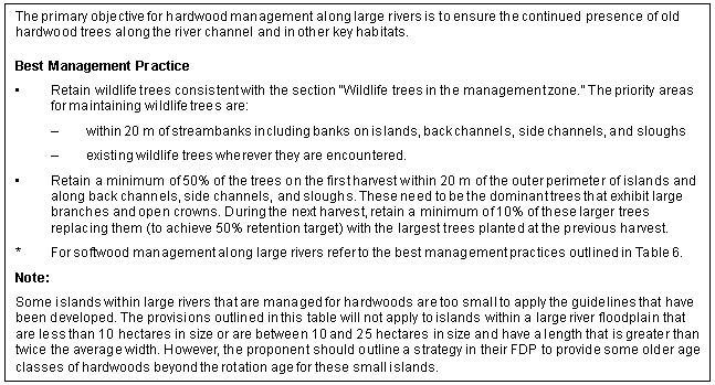
Achieving riparian management area objectives for floodplains of large rivers such as the lower Fraser, Homathko, Kingcome, and Skeena rivers, requires a different management approach than that specified for other stream RMAs. Large rivers are a special category of S1 streams in which woody debris no longer plays the essential role that it does in smaller channels. In smaller channels, trees that enter the stream can span the channel or form jams where it can then contribute to the creation of fish spawning, rearing, and overwintering habitat. A reserve zone is not required adjacent to large rivers and the management zone extends from the streambank to the outer edge of the active floodplain or to 100 m, whichever is greater.
In large rivers, only minor amounts of woody debris found in the stream or along the bank come from the immediate overbank area or are retained along the river's edge. In addition, the role that mature trees play in maintaining bank stability is reduced because the rooting depth of trees is often situated on unconsolidated materials well above the eroding zone of the stream edge. Riparian management guidelines for large river RMAs are distinct from those of other S1 RMAs. It is important that the wildlife riparian objectives are met in the management zone or elsewhere in the landscape on the same river and with similar ecosystems. Landscape level planning should be an essential part of meeting riparian objectives on large rivers.
The following guidelines apply to hardwood management within the RMA on large rivers and their associated active floodplain. Refer to the best management practices outlined in Table 6 (active floodplain) for softwood management.
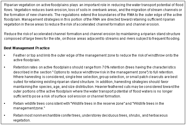
Table 6. Best management practices for active floodplains – coast and interior (for hardwood management on active floodplains, see Table 7)
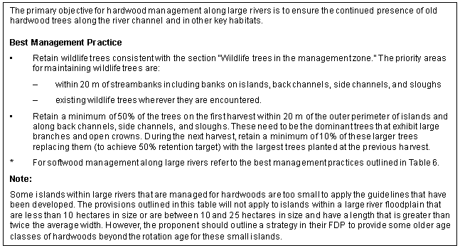
Table 7. Best management practices for hardwood management tenures* along large rivers – coast and interior
S4, S5, and S6 streams
Forest practices in the management zone adjacent to S4, S5, and S6 streams should be planned and implemented to meet riparian objectives including wildlife, fish habitat, channel stability, and downstream water quality.
Tables 8, 9, and 10 outline objectives and best management practices within the management zones of S4, S5, and S6 streams for the coast. Tables 11, 12, and 13 apply to the interior.
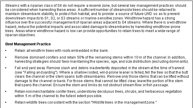
Table 8. Best management practices for management zones adjacent to S4 streams – coast
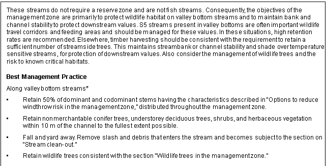
Table 9. Best management practices for management zones adjacent to S5 streams – coast
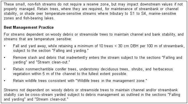
Table 10. Best management practices for management zones adjacent to S6 streams – coast
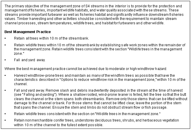
Table 11. Best management practices for management zones adjacent to S4 streams – interior
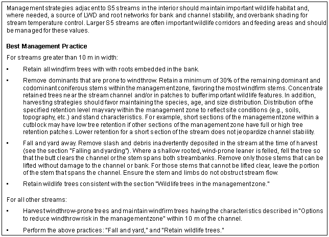
Table 12. Best management practices for management zones adjacent to S5 streams – interior
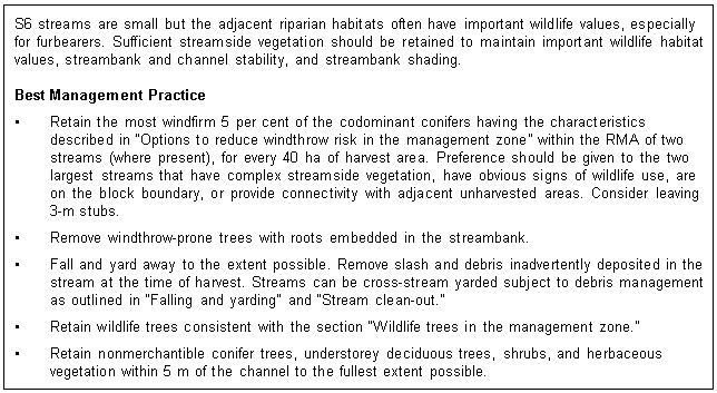
Table 13. Best management practices for management zones adjacent to S6 streams – interior
Wetlands and lakes
The following guidelines apply to the management zone of all wetlands (W1 to W5) and lakes (L1 to L4).
The objectives of the management zone adjacent to wetlands and lakes is to protect the integrity of the reserve zone where one is required, and to maintain important wildlife values where no reserve zone is required.
Tables 14 through 16 outline guidelines for management zones adjacent to all wetlands and lakes. Wetlands and lakes have been separated according to their frequency on the landscape. In biogeoclimatic units where wetlands and lakes are uncommon, individual wetlands or lakes have greater importance for wildlife than where they are common.
Retention percentages for the management zone for dominant and codominant trees in Tables 14, 15, and 16 are for the harvest area (cutblock) and not the entire wetland RMA. Residual trees should be concentrated near the wetland or reserve zone but should also be used to provide no-work zones to protect wildlife hazard trees, and other wildlife features such as trails, moist sites, and deciduous patches.
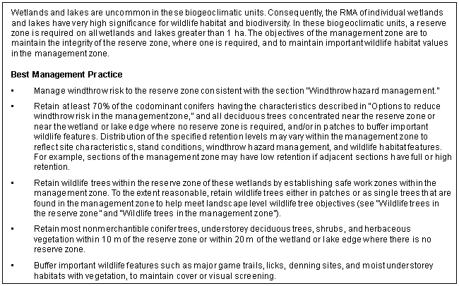
Table 14. Best management practices for the management zone adjacent to wetlands and lakes in the CDF, PP, BG, CWHxm, dm, ds, and IDFxh, xw, xm biogeoclimatic units
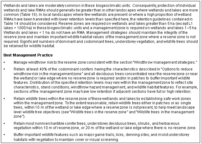
Table 15. Best management practices for the management zone adjacent to wetlands and lakes in the ESSF, MS, ICH, MH, CWHvm, mm, ms, ws, and IDFdm, dk1, dk2 biogeoclimatic units
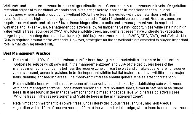
Table 16. Best management practices for the management zone adjacent to wetlands and lakes in the SWB, SBS, SBPS, BWBS, CWHvh, and IDFww, mw, dk3, dk4 biogeoclimatic units, except large (>1000 ha) bog and muskeg dominated wetlands
Range in riparian areas
Objectives
The objectives for riparian areas (see "RMA objectives") are the same for range use as for other forest practices. Due to the unique effects and management constraints of range use compared to other forest practices however, guidelines to achieve riparian area objectives are presented separately for range use.
Riparian areas provide important watering sites for livestock and, in some parts of the province, significantly contribute to livestock forage. Riparian areas are also especially sensitive to range use practices. As a result, riparian areas are often the focus of range management planning and should be given special consideration when developing range use plans.
Stream, wetland, and lake riparian areas should be managed as part of the larger pasture. Range use plans for a pasture should be designed to meet riparian as well as upland objectives. In many cases, range use schedules and objectives may be determined primarily by riparian objectives. In cases where it is not possible to meet riparian objectives through broader pasture management practices, it may be necessary to restrict cattle use by fencing or other means.
Range guidelines differ in important aspects from those for other forest practices:
- Range guidelines are applied to riparian areas (as defined by regulations) rather than to riparian management areas (RMAs). Riparian areas include the stream, wetland, or lake and the adjacent moist area where vegetation is distinct from that of the surrounding uplands. Unlike RMAs, riparian areas do not have a specified width. Their width is the width of the vegetation that is distinct from the uplands.
- Range guidelines are based on riparian habitat units and the maintenance of key attributes within these habitat units rather than on stream width or wetland/lake area. To apply the range guidelines, it is necessary to identify habitat units (areas of relatively uniform vegetation and site), but it is not necessary to identify the riparian class of streams, wetlands, and lakes as described earlier in this guidebook. This approach is adopted to focus range guidelines on those attributes that are most likely affected by range use.
- Range guidelines focus on the condition of riparian habitat unit attributes rather than on management strategies for riparian areas. Therefore, an essential aspect of the range guidelines is monitoring of habitat conditions.
- Although the range guidelines presented in this section contain quantitative criteria for monitoring riparian attributes, in most cases the range manager will be aware, based on personal experience and normal observations, where range use effects are exceeding guideline conditions. In only a few circumstances should it be necessary to apply quantitative criteria for monitoring range use effects.
Range habitat units
Range habitat units are the basic unit for application and monitoring of range guidelines for riparian areas. They are areas of sufficiently homogeneous vegetation and site conditions to be a meaningful basis for detecting and assessing the effects of range use on riparian area attributes. For streams, habitat units should be stream reaches as described in "Classifying streams." For lakes, two habitat units should be defined—the shallow (< 2 m deep) lake edge and the deeper portion of the lake. For wetlands and for areas adjacent to streams, wetlands, and lakes, habitat units are areas of relatively uniform vegetation and site conditions and are usually identified and mapped by dominant plant species. They should also be referenced to the biogeoclimatic unit in which they occur. A forested habitat unit should have uniform dominant tree species and a relatively uniform understorey vegetation. A shrub dominated unit should have uniform dominant shrub species and a relatively uniform herbaceous vegetation. Meadow, grassland, and other herbaceous habitat units should have relatively uniform dominant herbaceous species.
Examples of habitat units include:
- mature spruce – black twinberry forest on a floodplain in the IDFxm biogeoclimatic unit
- water birch – willow riparian shrubland adjacent to intermittent stream in the BGxh biogeoclimatic unit
- spreading needlegrass – arctic rush meadow adjacent to a wetland in the BGxw biogeoclimatic unit
- cattail marsh in the IDFxh biogeoclimatic unit
- willow – sedge fen in the SBSmc biogeoclimatic unit.
Range habitat units in riparian areas are grouped into two broad ecosystems for the purposes of the range guidelines:
- stream, wetland, or lake
- moist riparian ecosystem.
Streams, wetlands, and lakes are defined earlier in this guidebook.
Moist riparian ecosystems include moist lower slopes and terraces (hygric or subhygric ecological moisture regime) that border the stream, wetland, or lake and have vegetation distinct from that of the surrounding uplands. These ecosystems are transitional between the wet aquatic feature (stream, wetland, or lake) and the drier surrounding uplands.
Although upland ecosystems are not part of the riparian area as defined by the regulations, those upland ecosystems immediately adjacent to the riparian area should be included in the application and monitoring of range guidelines. Achievement of riparian objectives may be affected by management practices on these upland ecosystems. Upland ecosystems include drier (mesic or drier ecological moisture regime) sites where the vegetation is characteristic of the relatively well-drained surrounding uplands.
Each of these broad ecosystems contains one or more range habitat units.
Properly functioning condition
Range use practices will meet riparian area objectives when they maintain properly functioning condition of each habitat unit. Properly functioning condition is maintained where the effects of range use on habitat attributes are 1) on average, small or within the range of natural variability of the habitat unit and 2) are large and beyond the range of natural variability in no more than a small portion of the habitat unit. If the effects of range management are within the range of natural variability over most of the habitat unit, it is likely that the natural ecological functions of the habitat unit will be maintained.
The components of properly functioning condition are described in the following sections. Guidelines for assessing properly functioning condition are described in the section on "Range use in riparian areas."
Desired plant community
Vegetation is a principal habitat attribute that should be evaluated when assessing or monitoring the properly functioning condition of any habitat unit. Vegetation is a principal determinant of wildlife and fisheries habitat value and is also a useful indicator of riparian ecosystem function. Vegetation condition should be evaluated by comparing the composition and structure of the current grazed vegetation to the composition and structure of the desired plant community (DPC).
The DPC is the target plant community of a habitat unit that is to be achieved and maintained through application of the range use plan. The DPC should have the same or very similar composition and structure as the 'natural' plant community (potential natural community), that is the plant community that would dominate the habitat unit had it not experienced domestic livestock use. The DPC should only differ from the 'natural' plant community in those cases where past management practices have resulted in the establishment of non-native species (such as Kentucky bluegrass), which cannot practically be replaced by natural processes. In many cases, the 'natural' plant community can only be estimated, especially if the area has been grazed for many years and similar but ungrazed or very lightly grazed sites (such as enclosures) are not present nearby. For purposes of range guidelines, the 'natural' plant community includes the effects of forest practices other than range use.
The DPC should be described in the range use plan in terms of species composition and vegetation structure. Species composition descriptions should include approximate abundance (per cent ground/canopy cover range) of each principal tree, shrub, grass, and forb species and combined moss and combined lichen species. Vegetation structure descriptions should include the approximate amount (per cent ground/canopy cover) and foliar development of each of the following vegetation layers:
- trees (woody plants >10 m tall)
- tall shrubs (woody plants 2–10 m tall)
- low shrubs (woody plants <2 m tall)
- herbaceous plants
- mosses and lichens.
The DPC description should also include the approximate amount (per cent) of exposed mineral soil.
In practical application, it is neither necessary nor feasible to define in detail the DPC and other attributes of properly functioning condition for all range habitat units within the range tenure area. The range manager will generally be aware of those range habitats that are, or likely will be, most affected by range use. These habitat units should be identified and given priority for establishing DPCs and for systematic monitoring of riparian vegetation.
Other components of properly functioning condition
Properly functioning condition also depends on the maintenance of other riparian attributes whose condition in a pasture unit should be assessed relative to their 'natural' condition in the absence of grazing. These attributes include, but are not limited to:
- streambank stability and form
- streambank shading
- extent of soil disturbance resulting from trampling
- degree surface erosion and sedimentation
- quantity and quality of water in streams, wetlands, and lakes
- maintenance of wildlife habitats
- amount of browsing.
Range use in riparian areas
General guidelines
The following general guidelines address range use practices within and immediately adjacent to riparian areas. Elaboration on these guidelines can be found in the Range Management Guidebook.
- Range use should be tailored to site-specific conditions, objectives, public concerns, and livestock management limitations.
- Range use should be prescribed through the range use plan.
- The range use plan must prescribe the levels of utilization for key plant indicator species within the riparian area.
- The range use plan should identify range readiness criteria including key plant indicator species and soil parameters.
- The grazing schedule should allow period(s) of rest during times of critical plant growth and regrowth; periodic and systematic rest from livestock grazing should be employed wherever possible.
- Season-long continuous grazing should not be authorized unless it is consistent with achieving properly functioning condition and meeting identified riparian area objectives.
- Within the riparian area, utilization and residual targets should be applied that will, where the potential exists, improve or restore herbaceous and woody species to:
- a healthy and vigorous condition, and allow vegetation to reproduce and maintain different age classes according to a DPC
- leave sufficient vegetation biomass and residue to provide for adequate sediment filtering and dissipation of stream energy for bank protection
- Roads and trails required for range management purposes should not occur in riparian areas except where necessary to cross these areas.
- Corrals should not be placed within 50 m of streams, wetlands, and lakes, and should be located on dry upland sites with no drainage from the corral into the riparian feature.
Riparian area target conditions
Tables 17–20 describe target conditions for key riparian area attributes and should be used as a basis for assessing properly functioning condition. In most cases, qualitative assessments by knowledgeable individuals will adequately assess whether the intent of these riparian targets have been met. Only in a few cases should systematic, quantitative assessments, requiring a large systematic sample, be required.
In all cases, it is the responsibility of the range tenure holder or B.C. Ministry of Forests to ensure that riparian objectives for range use are being met in all habitat units. However, the range manager will generally be aware of those habitat units that are, or likely will be, most affected by range use. These habitat units should be identified and given priority for systematic monitoring of range use effects. Other habitat units should be observed frequently in the course of normal range management operations. Where observations suggest that riparian objectives may not be met or are near the limits of acceptability, the habitat unit should be assessed and monitored more systematically.
In many cases, current habitat conditions do not meet the targets outlined below. In these cases, the habitat unit and its current conditions should be identified and managed for the target condition. The rate of recovery towards the target should, in general, be approximately 75 per cent of that achieved under total cattle exclusion.
The range tenure holder should contact BC Environment and the B.C. Forest Service regarding values associated with specific riparian areas and appropriate measures to protect these values.
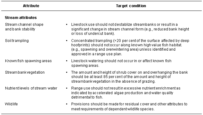
Table 17. Target conditions for range use of stream riparian areas
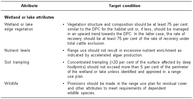
Table 18. Target conditions for range use of wetland and lake areas
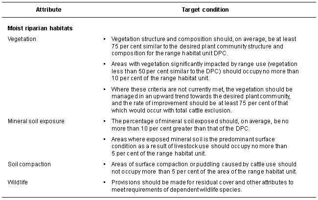
Table 19. Target conditions for range use of moist riparian habitats
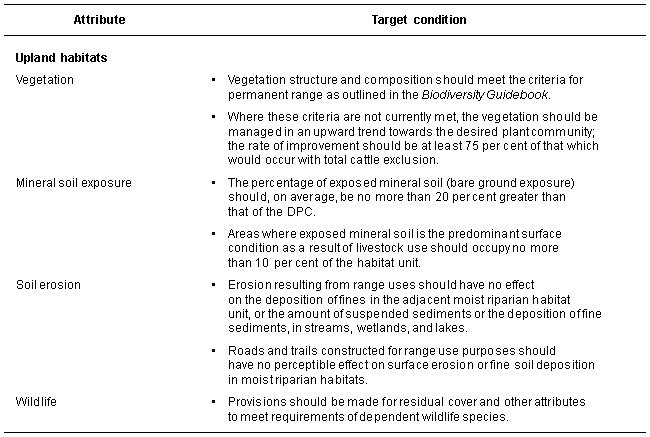
Table 20. Target conditions for range use of upland habitats
Restoration and remedial measures
Where restoration or remedial measures are required to meet objectives for riparian areas, measures may include:
- changing utilization and residual targets for plant indicator species
- changing the intensity of use
- changing the grazing schedule to:
- redefine vegetation and soil criteria for range readiness to eliminate use during unsuitable seasons
- provide periods of rest during times of critical plant growth (examples of possible grazing systems are rest-rotation grazing, deferred-rotation grazing, and time-controlled grazing)
- altering livestock distribution through the use of fences, riders, off-stream watering, and salt
- mechanical and structural stabilization of banks (subject to regulations and acceptability)
- planting and seeding (native species preferred)
- using natural, rocky areas for livestock watering to reduce trampling damage and loitering.
Appendix 1
Wetland classes
The national wetland classification recognizes five major classes of wetlands. [1, below]
Shallow open water wetlands are intermittently or permanently flooded areas with open expanses of standing or moving water up to 2 m deep. Open water, with no emergent vegetation, covers 75 per cent or more of the wetland surface. These wetlands are commonly termed ponds or pools.
Marsh wetlands have mineral or sometimes well-decomposed peat soils. When peat soils are present they are often enriched with mineral materials. Waters are nutrient rich with near-neutral to basic pH. Surface water levels typically fluctuate seasonally, with declining levels exposing matted vegetation or mudflats. Emergent vegetation includes grasses, cattails, sedges, rushes, and reeds which cover more than 25 per cent of the wetland surface.
Swamp wetlands have mineral or occasionally peat soils with a water table at or near the surface. There is pronounced internal water movement from adjacent mineral areas, making the waters nutrient-rich. If peat is present, it is mainly well-decomposed wood and occasionally sedges. The vegetation is typically dominated by coniferous or deciduous trees or dense shrubs and herbaceous species.
Fen wetlands have organic soils and a water table at or above the surface. Soils are primarily moderately to well-decomposed sedge and non-sphagnum moss peats. Waters are mainly nutrient rich with a near neutral to slightly acid pH. The vegetation consists primarily of sedges, grasses, reeds, mosses, and some shrubs. Scattered trees may be present.
Bog wetlands have organic soils with a water table at or near the surface. Soils are predominantly poorly to moderately decomposed sphagnum moss peats. The bog surface is usually unaffected by groundwaters and thus waters are generally acid and low in nutrients. Bogs are usually carpeted by sphagnum mosses and ericaceous shrubs. They may be treed or treeless. Bogs with an open growth of scrubby trees are commonly referred to as muskeg.
[1] Tarnocai, C. and others. 1988. The Canadian wetland classification system. In National Wetlands Working Group. Wetlands of Canada. Ecological Land Classification Series No. 24. Sustainable Development Branch, Environment Canada, Ottawa. pp. 413–427.
Appendix 2
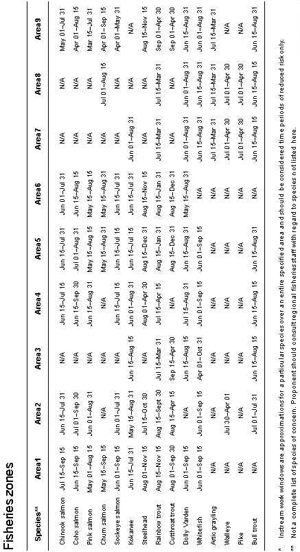
Appendix 2. Instream work window for provincial fisheries zones*
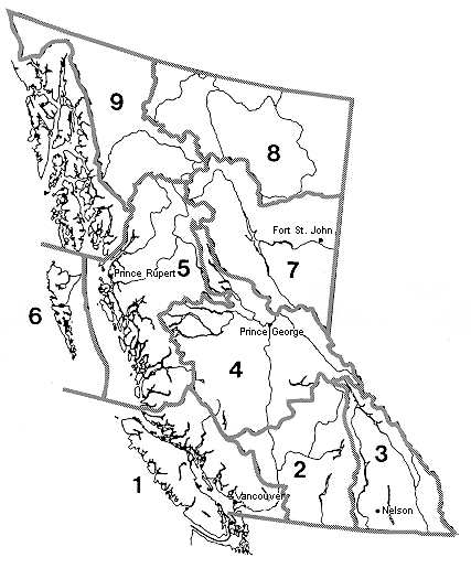
Figure 2-A. Map of provincial fisheries zones.

