Surficial mapping
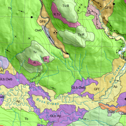
Surficial materials are relatively young unconsolidated sediments. By describing the texture, composition, chemistry, stratigraphy, three-dimensional geometry, and morphologic expression of these sediments, geologists attempt to reconstruct how BC's landscape has evolved through repeated glacial and interglacial states in the last 2.6 million years
Detailed study of surficial materials can help distinguish agents of erosion, transport, and deposition (water, wind, ice, gravity), quantify the physical conditions under which landforms developed, and thereby document past paleogeographic elements and depositional systems. Such paleogeographic reconstructions have predictive value, enabling geologists to extrapolate interpretations based on surface data into the subsurface and laterally into unknown areas. They are particularly useful in the search for mineral and aggregate deposits, suitable construction sites, and natural hazard mitigation.
Map index
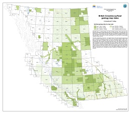
Presented here is a surficial geology map index for British Columbia. These maps have been produced by the British Columbia Geological Survey, the Geological Survey of Canada (GSC), and Geoscience BC. To be included in this index maps have to be available for download. Each map is represented by the actual map extent or footprint rather than a bounding box or NTS sheet that it falls within. This provides an accurate representation of the areal extent of surficial geology mapping for British Columbia.
The index is presented by map scale. In the digital versions of this index advanced searches can also be conducted on fields such as source author, source type (data available in digital or PDF form), or source series (Preliminary maps to A Series or Geoscience maps) to name a few. Publication page URLs are supplied for each map where the source files, PDFs or digital data can be downloaded. Also included is supplemental information which, when applicable, states where data are originally from and/or have elsewhere been used. Instances of this would be when an author published a map which was then revised and published as a GSC A Series map or when a map was used in a subsequent compilation. When this has occurred not only are the publication numbers provided for these other maps but links to their publication pages as well. This enables users to see all sources of the same data. In some cases original mapping is only available as a PDF but a subsequent map or compilation has made it available as an attributed vector file (e.g., shapefile).
The index is available in PDF, ESRI Geodatabase, ESRI Map Package, Shapefile, and KMZ formats
The map index is updated annually. The current version (v.2020-01 updated January 2020) is downloadable here.
Recommended citation: Arnold, H. and Ferbey, T., 2019. British Columbia surficial geology map index. British Columbia Geological Survey, Open File 2019-03 version 2020-01.
Mapping
Information about surficial materials in British Columbia is available from three types of maps: surficial geology, terrain, and soils.
Surficial Geology Maps
Surficial geology maps show the spatial distribution of surficial materials and their surface expression. As with any geological map, surficial geology maps are created by defining internally consistent map units, establishing the nature of map unit boundaries, and establishing map unit geometries. Units are defined by surficial material type and surface expression, using a closed legend.
Terrain Maps
Terrain maps are a specific type of surficial geology map. Not only do they show the distribution of surficial materials and describe their surface expression, they also characterize the geomorphological processes that have shaped, or continue to shape, the landscape. Some terrain maps include slope gradient, drainage, and slope stability classes. Map unit boundaries are based on surficial material type, surface expression, geomorphic process, slope, and drainage. These maps use an open legend in which a combination of characters describe each unit, as illustrated below. This map type can therefore have many unique polygons labels.
Soils Maps
Soil maps describe and classify those parts of the soil profile that support biologic activity, otherwise defined as the rooting depth of native perennial plants. This information is obtained by describing the basic soil unit, or pedon. Included in this description is the parent material for the A and B horizons. This parent material could be a C-horizon or bedrock. Map unit boundaries are based on soil association descriptions. Information on landform classification (i.e., surficial material type), surface form (i.e., surface expression) and topographic class (i.e., slope) is also included in map unit labels.
Similar to terrain maps, soil maps use an open legend in which map units are specified by a combination of characters.
Example of a surficial geology map and polygon label:
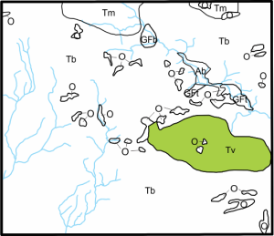
Information contained in the highlighted surficial geology map label:
 Till veneer (Tv; < 2m thick)
Example of a terrain map and polygon label:
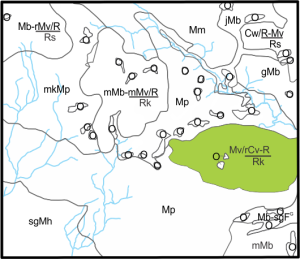
Information contained in the highlighted terrain map label:
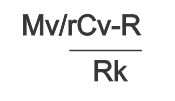
Morainal veneer (Mv; <2m thick) and discontinuous colluvial veneer (<2 m thick) derived from bedrock (/rCv-R) overlying bedrock on a steep slope (Rk).
For further information, visit the Ministry of the Environment, Ecosystems Branch terrain website.
Example of a soil map and polygon label:
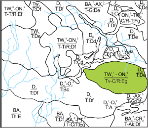
Information contained in the highlighted soil map label:
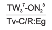
70% Twain soil (TW3 - luvisolic humo-ferric podzol, moderately well drained and derived from loamy morainal veneer) and 30% Oona soil (ON2 - mini humo-ferric podzol, degraded dystic brunisol, derived from shallow moderately coarse to medium textured colluvium and detritus over basic bedrock), overlying till veneer and colluvium over bedrock (Tv-C/R) on a strongly sloping and hill (:Eg).
For further information, visit the soil mapping and related standards website of the Ministry of the Environment, Ecosystems Branch
Contact our Quaternary Geologist
