Get prepared for a tsunami

Tsunamis are most often caused by huge undersea earthquakes that cause large waves. It may take hours for waves to reach the shore if an earthquake happens far away. Strong earthquakes near land could generate a tsunami that arrives in just minutes.
On this page
- If you're near the coast and feel an earthquake
- Tsunami notification zones
- How to get information
- Types of tsunami alerts
If you're near the coast and feel an earthquake
If you are near the coast when an earthquake occurs, Drop, Cover and Hold On. When the shaking stops, get to higher ground to protect yourself from a potential tsunami.
In coastal areas without evacuation maps, plans or cell service, move as high or far inland (away from the water) as possible.
In areas with evacuation maps, plans and cell service, move to high ground following your designated tsunami evacuation route. Follow all instructions from local officials.
Once you are at high ground, stay there until you receive the "all clear" message from local officials, tsunami waves can last several hours. Never go to the beach to watch the waves. A tsunami can move faster than you can run.
Tsunami notification zones
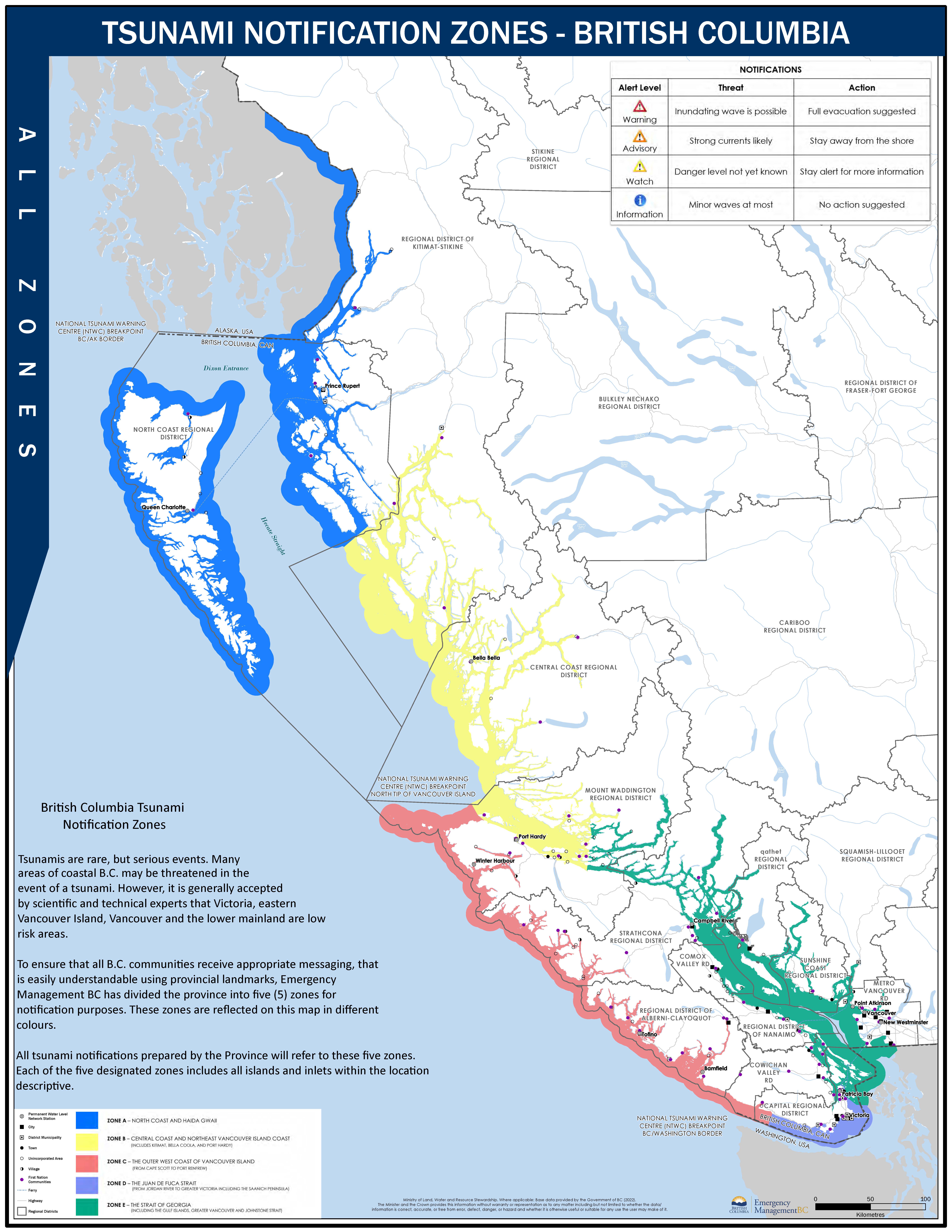
Our coastal communities are divided into five tsunami notification zones. Knowing your zone will help when a Warning, Advisory or Watch is issued for your area. Use the maps below to identify your zone then check in with your local authority about your community's tsunami plan, evacuation routes and high ground locations.
Tsunami Notification Zone A - map (PDF, 1.7MB)
- North coast and Haida Gwaii
Tsunami Notification Zone B - map (PDF, 2.6MB)
- Central coast and northeast Vancouver Island coast including Kitimat, Bella Coola, and Port Hardy
Tsunami Notification Zone C - map (PDF, 2.8MB)
- West coast of Vancouver Island from Cape Scott to Port Renfrew
Tsunami Notification Zone D - map (PDF, 1.2MB)
- Juan de Fuca Strait from Jordan River to Greater Victoria (including the Saanich Peninsula)
Tsunami Notification Zone E - map (PDF, 3.2MB)
- Strait of Georgia (including the Gulf Islands)
- Greater Vancouver and Johnstone Strait
Practice your tsunami evacuation route. High Ground Hike is a yearly event encouraging residents of coastal communities to practice getting to their high ground location.
How to get information
If you live in a tsunami notification zone and a Tsunami Warning is issued, the warning will be broadcast across television, radio and compatible mobile devices through B.C.'s emergency alert system.
Your local authority may also have its own alerting system, including sirens, and will be sharing information via social media, phone, text message, door knocking, local radio and TV. Contact your local authority in advance to find out what will be used in your community.
Once a Tsunami Warning has been issued, it is important to follow directions from your local authorities. You should also follow official sources of information like EmergencyInfoBC.
Types of tsunami alerts
| Alert Level | Threat | Action |
|---|---|---|
 WARNING WARNING |
Flood wave possible | Full evacuation suggested |
 ADVISORY ADVISORY |
Strong currents likely | Stay away from the shore |
 WATCH WATCH |
Danger level not yet known | Stay alert for more information |
 INFORMATION STATEMENT INFORMATION STATEMENT |
Minor waves at most | No action suggested |
 CANCELLATION CANCELLATION |
Tidal gauges show no wave activity | Confirm safety of local areas |

