Central Okanagan Data
The Central Okanagan planning study has revealed that the majority of the traffic in the region is local. As the largest concentration of population and employment in the region, Kelowna has a major influence on travel patterns in the Central Okanagan and is the primary destination for those arriving from outside the region.
Traffic
Over 25,000 vehicles/day enter the Central Okanagan, most destined for Central Okanagan communities. The W.R. Bennett Bridge carries mostly traffic from within the region. Only about one-third of all vehicles entering the Central Okanagan actually cross the bridge. Nearly half the traffic entering from the south ends up in Peachland, West Kelowna or Westbank First Nation, and more than three-quarters of the traffic from the north goes no further than Kelowna.
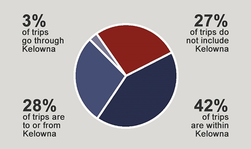
Among all the trips in the Central Okanagan (whether originating within or outside the region) nearly three-quarters involve Kelowna in some way.
- 42% of trips are contained within Kelowna
- 28% are going to or from Kelowna
- 3% are just passing through
- 27% of trips in the region do not involve Kelowna

Traffic patterns typically fall into three major categories:
- Urban – notable AM and PM peaks with sustained high traffic volumes during the day
- Suburban – very pronounced AM and PM peaks, with lower traffic mid-day and high Saturday traffic
- Non-Urban / Rural – no notable peak hours, traffic builds in the morning, then stays steady through the day
W.R. Bennett Bridge
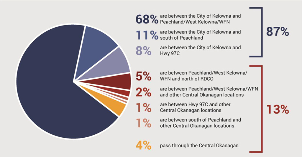
The distribution of trips crossing the W.R. Bennett Bridge was also examined to determine regional travel patterns. These identified patterns are shown below:

The vast majority of trips (87%) that cross the bridge involve the City of Kelowna as either an origin or destination. Only 4% of the trips that cross the bridge pass through the entire Central Okanagan Region; down from 15% in 1994. This indicates that over the last 20 years, the crossing has had an increasing importance as a local/regional connection as opposed to a through traffic route.
Population
In 2014, the population of the Central Okanagan was 187,058 with the vast majority located in Kelowna and West Kelowna. By 2034, population is expected to grow to nearly 255,000, an increase of more than 36% in 20 years. Over the longer term (40-50 years), the population is expected to grow to 325,000.
The strongest employment growth sectors over the next 25 years are expected to be trade and health care. It is expected that commuting to and from work will continue to be a major part of the future transportation demand.
Planning for the Future
A future needs assessment was completed in 2015. By 2040, it is expected that both the W.R. Bennett Bridge and the highway on the Kelowna side will be at capacity. A trip along the full length of the corridor (between Peachland and Lake Country) will take almost 15 minutes longer in the AM peak hour and up to 24 minutes longer in the PM peak hour. Almost all signalized intersections within developed areas will have significant congestion. Congestion will continue to be the result of local and regional trips.
The Central Okanagan transportation plan will be developed in alignment with local and regional transportation plans. We will conduct further studies to assess localized needs.
Key elements to existing corridor concepts include:
- Removing traffic signals
- Reducing conflicts at high collision locations
- Maintaining local connections for all modes across the highway as much as possible
- Accommodating and supporting uncongested, reliable transit on the highway
The study has identified alternate corridor concepts that include:
- Diverting traffic away from the existing corridor to provide relief
- Creating connections to the existing corridor
- Meeting high-speed design criteria
Options to meet future mobility needs will need to take into account a wide range of considerations, including:
- Congestion reduction techniques
- Land use impacts
- Environmental protection (air quality, emissions, habitat)
- Local economy
- Goods movement
- Tourism, recreation & health
- Community liveability
- Heritage & archaeology
- Affordability & cost
For more detailed information about future needs see Future Corridor Conditions – Detailed Technical Report – December 2016
Subscribe
Enter your email address to subscribe to updates of this page.

