Lesson 1: What is Karst?
On this page
- Lesson objectives
- A type of topography
- How karst forms
- Karst in cross-section
- Karst as a wetland
- Karst hydrological systems
- What is a karst ecosystem?
- What is a forested karst ecosystem?
- Test your knowledge
Lesson objectives
Lesson 1 provides a general introduction to karst. The term karst is used to describe a landscape of distinctive landforms and underground drainage. Karst landscapes include an interconnected network of soluble bedrock, water, soil, flora, and fauna. In B.C., “karst resources” refers to all components of a karst ecosystem.
By the end of this lesson, you should be able to:
- Define karst
- Describe how karst forms
- List some of the most common karst-forming rocks
- Describe the physical structure of karst in cross-section
- Explain why karst is classified as a subterranean wetland by international convention
- Describe the basic hydrology of karst systems
- List the main components of a karst ecosystem
- Explain why trees and vegetation are important components of forest karst ecosystems
A type of topography
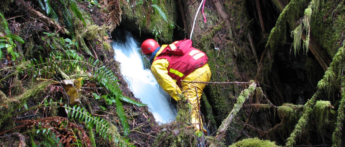
Karst forms when soluble bedrock is dissolved by water. Existing fractures and cracks in the bedrock become enlarged through dissolution. Over time, extensive subterranean drainage networks develop to connect the surface with the subsurface.
The dissolving action of water also creates distinctive surface karst features such as dolines (karst sinkholes), karst canyons, karst springs, sinking streams, and fluted bedrock surfaces.
Soluble rocks in which karst typically forms include:
- Limestone
- Marble
- Dolomite (or dolostone)
- Halite
- Gypsum
Limestone, marble, and dolomite are the most common karst-forming rocks in B.C. There are also areas of gypsum karst in the northwest and southeast corners of the province.
Did you know? Soluble bedrock must be present for karst to form, but the presence of soluble rock does not necessarily mean that karst is present.
To be considered karst, soluble bedrock must exhibit internal drainage, and at least some distinguishable karst features must be present. Bedrock mapping alone does not necessarily mean karst is present, it can only show those areas where potential karst development might occur. Remote sensing technologies, such as satellite imagery, can help to establish whether karst is present in an area, but sometimes ground searching is needed for confirmation.
How karst forms
Karst forms when water dissolves soluble bedrock, but the process can vary depending on the chemical make-up of the rock. For example, water must be slightly acidic to dissolve carbonate rocks such as limestone, marble, and dolomite.
Rainwater becomes weakly acidic as it absorbs small amounts of carbon dioxide (CO2) while falling through the atmosphere. The water picks up much more CO2 after it hits the ground and percolates through the soil. By the time the water finally flows into the fissures and joints in carbonate bedrock, it is acidic enough to dissolve the bedrock. The chemical process is shown below:
CaCO3 (solid) + H2O + CO2 (dissolved) ⇌ Ca2+ + 2HCO3-
↿⇂
CO2 (air)
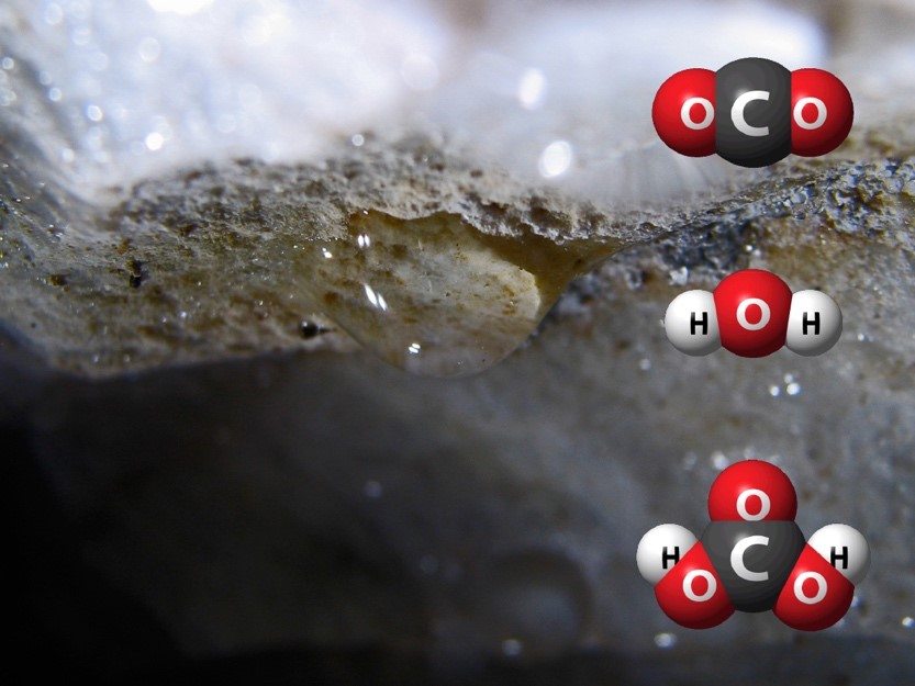
Carbon dioxide (CO2) + water (H2O) = carbonic acid (2HCO3). Illustration by P.A. Griffiths
As the bedrock dissolves, the fissures and joints in the rock start to enlarge. Over time, the landscape develops into the type of topography we call karst. The rates at which karst landscapes develop can be highly variable, depending on factors such as bedrock solubility, climate, precipitation and run-off, soil and vegetation cover and seismic activity, etc.
Did you know? Some types of bedrock are more soluble than others. For example, gypsum is much more soluble than limestone or marble and therefore develops more quickly into karst.
Limestone and marble consist mostly of calcium carbonate (CaCO3). When the calcium carbonate is dissolved away, there may be very little insoluble material left over to form soil. This is one of the reasons some karst areas have thin soils.
Karst in cross-section
In cross section, karst has two main “layers” or “zones.”
The uppermost zone is called “epikarst.” The surface of the epikarst contains many surface openings that connect to a network of cracks and fissures in the bedrock that have been enlarged by dissolution. The network of surface openings and enlarged fissures in the epikarst allow water to flow into the karst, dissolving the bedrock as it goes.

Photo by C.L. Ramsey
Below the epikarst is a deeper zone of bedrock that contains fewer but larger cavities and conduits. This deeper zone, called the “endokarst,” is where cave passages typically occur.
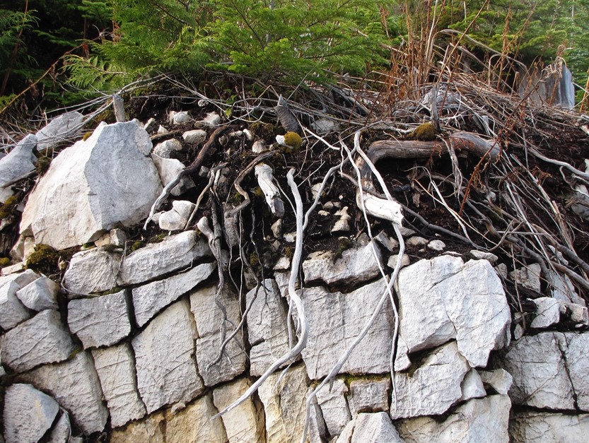
Photos by C.L. Ramsey
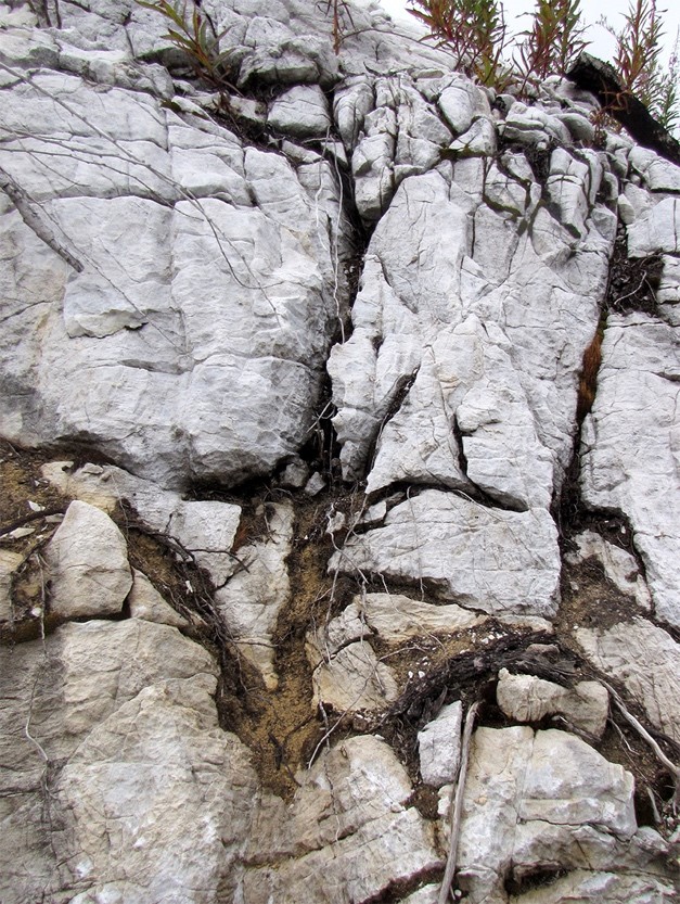
The permeable nature of karst causes it to function very differently than other types of landscapes. This is because water, soil, living things, and any chemicals or pollutants can be transferred down into the subsurface network of bedrock spaces by water and gravity. Although soil and vegetation can often make it difficult to see the porous nature of the epikarst, the transfer of water and materials into the subsurface occurs across most of the surface of a karst landscape.
Did you know? The structure of karst in cross section can sometimes be directly observed in quarries and road cuts. The general structure of karst is similar throughout the world, but the size and number of the openings in the epikarst and the relative depths of the epikarst and endokarst zones can vary from place to place.
Karst as a wetland
Water can enter the epikarst faster than it can drain out. The result is that water is temporarily stored within the small porous spaces in the epikarst before being slowly released downward into the larger cavities and conduits in the endokarst. The “water storage” capacity of karst is why some karst springs continue to flow even after long periods of drought.
Did you know? The ability to temporarily store water and serve as important habitat is why karst was included as a special kind of subterranean wetland by the Ramsar Convention on Wetlands in Brisbane, Australia in 1996.
Epikarst is sometimes definable as fish habitat under federal legislation. Many of the spaces in the epikarst where water is stored are important habitat for tiny animals like crustaceans. An example is the blind amphipod Stygobromus quatsinensis found in karst systems of Vancouver Island and Southeast Alaska. Entire communities of smaller organisms, like crustaceans, can inhabit water-filled spaces in the epikarst.
The Canadian Fisheries Act defines “fish habitat” as “spawning grounds and any other areas … that fish depend on directly or indirectly to carry out their life processes.”
Epikarst can meet the Canadian Fisheries Act definition of fish habitat since crustaceans are included in the Act’s definition of “fish.” However, it is not uncommon to see finfish in the waterfilled portions of some caves. An example is shown in the video clip below, filmed in a waterfilled passage in a Vancouver Island cave.
View Underground Fish Video Video by P.A. Griffiths
Karst hydrological systems
A karst hydrological system or “karst catchment” consists of all lands contributing surface runoff and/or diffuse recharge to a karst unit. Precipitation that falls directly onto a karst area and infiltrates the ground is referred to as “autogenic recharge.” Non-karst areas that contribute water to a karst unit are also part of the karst hydrological system. Water input from contributing non-karst areas is called “allogenic recharge.” Allogenic recharge may be concentrated into surface streams or rivers that flow onto the karst, where they often sink into the subsurface at features like dolines (karst sinkholes), cave entrances, or shafts.
Identifying the limits of a karst catchment can be a complicated task because:
- Subsurface flow paths within the karst cannot be directly observed
- Subsurface flow paths can change depending on the amount of water entering the karst system
Delineating karst hydrological systems is best entrusted to karst hydrologists who specialize in the study of how water moves through karst systems and are skilled in the use of dye tracing and other techniques to delineate karst catchments and understand subsurface flow paths under different conditions.
Natural disturbances and industrial activities in contributing non-karst areas can affect the karst unit downstream through the input of water or transported materials, such as pollutants, organic debris, or sediments.
Did you know? Subsurface drainage within karst is not necessarily influenced by surface watershed divides. Water that sinks into karst in one watershed can emerge on the surface in a completely different watershed. An example is water from Northern Vancouver Island’s Upper Benson River, which sinks into the Vanishing River cave system in the Benson River Valley. From there, it passes under a mountain range and reappears on the surface in the Raging River watershed about two kilometers away.
What is a karst ecosystem?
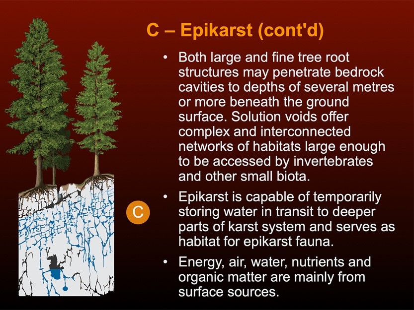
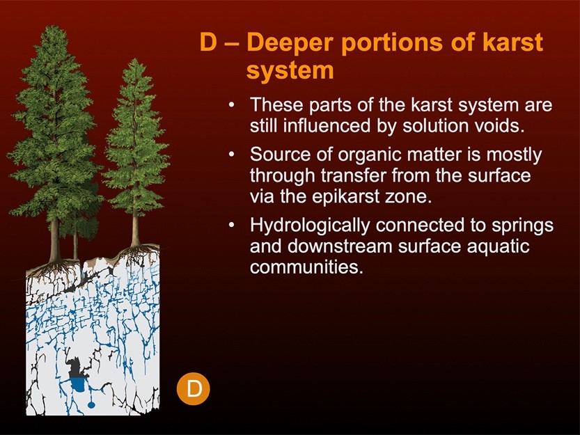
Like all landscapes, karst ecosystems consist of the sum of all living and non-living components, including soil, flora, fauna, water, air, and energy. However, karst landscapes are unique in that they include an extensive subterranean realm.
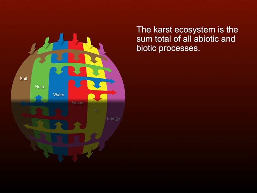
Illustration by P.A. Griffiths
What is a forested karst ecosystem?
The well-developed karst in Coastal B.C. and Southeast Alaska are excellent examples of highly productive forest karst ecosystems. These temperate rainforest karst ecosystems are globally rare.
Trees are an integral part of a forest karst ecosystem and play a critical role in buffering water inputs to forest karst systems through canopy interception and transpiration. In addition, most of the carbon dioxide that makes rainwater acidic enough to dissolve soluble bedrock comes from the forest litter and other organic matter in the soil. Large tree root masses and fallen trees help anchor the soil to control soil erosion and assist with regulating inputs of precipitation. Soil fauna and root respiration also contribute carbon dioxide to the karst-forming process. Shade from the forest canopies along with organic matter deposited to the forest floor help cool the soil and retain moisture.
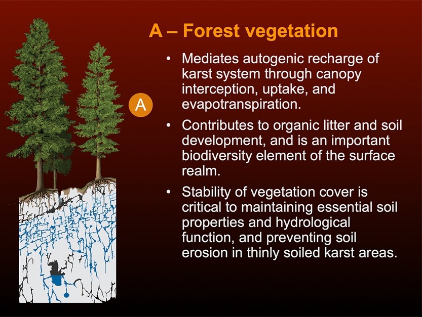
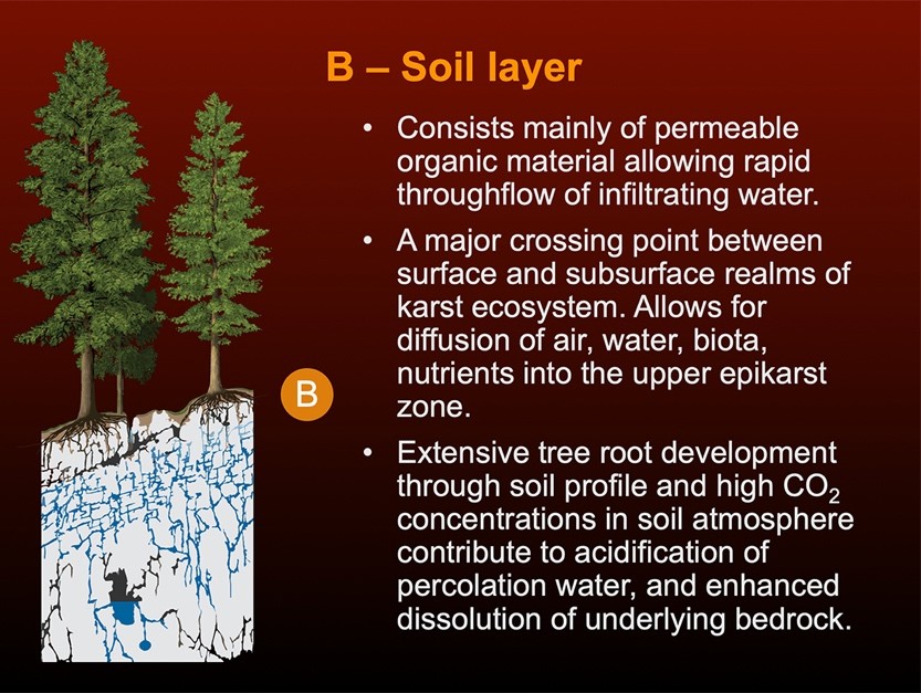
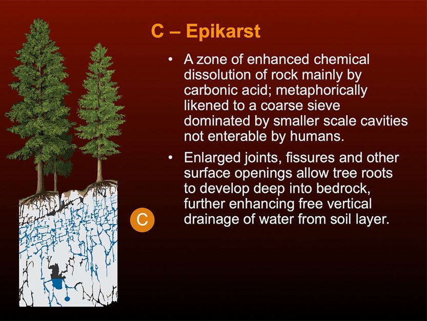
Illustrations by P.A. Griffiths
Test your knowledge
Self test (True or False)
Answer either True or False to check your understanding:
-
Precipitation that falls directly onto a karst area and infiltrates the ground is known as “allogenic recharge” of the karst hydrological system.
-
Forest vegetation on karst acts to do the following: a) provides canopy interception, uptake and evapotranspiration of precipitation; b) contributes to organic litter, soil development, and surface biodiversity, and c) maintains soil properties and hydrologic function such as preventing soil erosion in thinly soiled karst areas.
Answers
-
False. Precipitation that falls directly onto a karst area and infiltrates the ground is referred to as “autogenic recharge.” Water input from contributing non-karst areas is called “allogenic recharge.” Allogenic recharge may be concentrated into surface streams or rivers that flow onto the karst, where they often sink into the subsurface at features like dolines (karst sinkholes), cave entrances, or shafts. These non-karst areas contribute water to a karst unit are also part of the karst hydrological system.
-
True: Trees and other forest vegetation play a critical role in buffering water inputs to forest karst systems through canopy interception and transpiration. Large tree root masses and fallen trees help anchor the soil to control soil erosion and assist with regulating inputs of precipitation. Soil fauna and root respiration also contribute carbon dioxide to the karst-forming process. Shade from the forest canopies along with organic matter deposited to the forest floor help cool the soil and retain moisture.

