Cariboo-Chilcotin Natural Resource District road safety information
On this page
Hazard Warnings/Notices
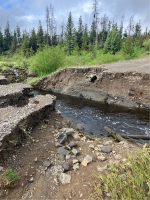
Clusko River – Aneko Creek FSR (4600rd) - Project#: 7356.04
The road is temporarily closed at approximately 13km due to a rain event which has caused a major washout. The FSR is NOT passable to any vehicles at this time. Alternate to the area access beyond 13km is available via the Alexis Lakes Public Road off of Hwy 20 west of Alexis Creek.
There is no current timeline for repairs.
Photo at right from June 2024.

Elkin-Creek River FSR (Lord River Road) – Project #: 4953.03
Road sustained damage in 2019, but upon last inspection, the road remains accessible to 4-wheel drive high-clearance vehicles. Bridges/Structures on the FSR have a 5-tonne load limit, but road users should note, several other bridges on adjacent private and mines access roads beyond the FSR should be considered potentially unsafe and not recommended for use.
Please note, a new gate, managed by the Xeni Gwet'in First Nations, has been installed at the start of the road, as approximately 7.5km of the Lord River Road is within the Title Lands. Please contact the Xeni Gwet'in Government office at 250-394-7023 for more information or visit their website: www.tsilhqotin.ca/declared-title-area
Fish Lake FSR – Project #: 9245.01
Road sustained damage in 2019, but upon last inspection, the road remains accessible to 4-wheel drive high-clearance vehicles. There is no current timeline for repairs.
Mosley Creek FSR – Project #: 7651.01
Road is closed at 6.6 km (private gate location) and beyond due to public safety. The Hell Raving Creek bridge at 15.1 km is closed due to safety issue, and has been down-rated to a 0-tonne load limit due to non-standard construction. No access is permitted beyond 6.6 km. There is no current timeline for repairs.
Mosely Creek – Hell Raving Creek – Project#: 7651.04
Road is temporarily closed at 0km due to the potential risk to road users from damage associated with a 2023 wildfire in the area. There is no current timeline for repairs.
Alex Graham – Palmer Lake FSR – Project#: 5265.02
Road is closed to vehicle traffic at approximately 70km (bridge crossing) for Access Management as it pertains to wildlife/habitat protection. There is no timeline for removal of the closure.
Road closures
Map of current closures in the Cariboo Natural Resource Region
Beece Creek Road (non-status road)
The former mining access road has been deactivated and permanently closed 6km beyond the Taseko Lake Lodge for public safety and environmental protection.
Black Creek - Cruiser Lake FSR - Project #: 1253.05
The southern section of the road has been deactivated and is permanently closed for approximately 1.5km as a part of the Fish Passage Restoration Program conducted by the Canadian Wildlife Federation. Alternate access to Boscar Lake is still available via from the North end of the FSR from the Black Creek – Bosk Lake FSR (500rd).
Harvey’s Creek FSR (9600 Road) – Project #: 8389.01
This road has been deactivated and permanently closed from 15 km to 16.3 km for public safety and environmental protection.
Work in-progress/upcoming works
Anahim Connector Route
The proposed project is still in the preliminary stages, and there are no timelines for construction. Additional information will be posted once it is available. Contact Conrad Cofre, Resource Manager, for further information.
Road deactivation
Moffat-Lake-Spokin FSR 7968.06
This route has been deactivated. ATV use only. Barricades have been placed at the point of entry, the road has been cross-ditched and the bridge at 1.5 km across Borland Creek has been removed.
Important resources
Contact information
Please report any road safety issues to the Cariboo-Chilcotin Natural Resource District office.
