Hatzic Valley Emergency Works
Area: Hatzic - Mission
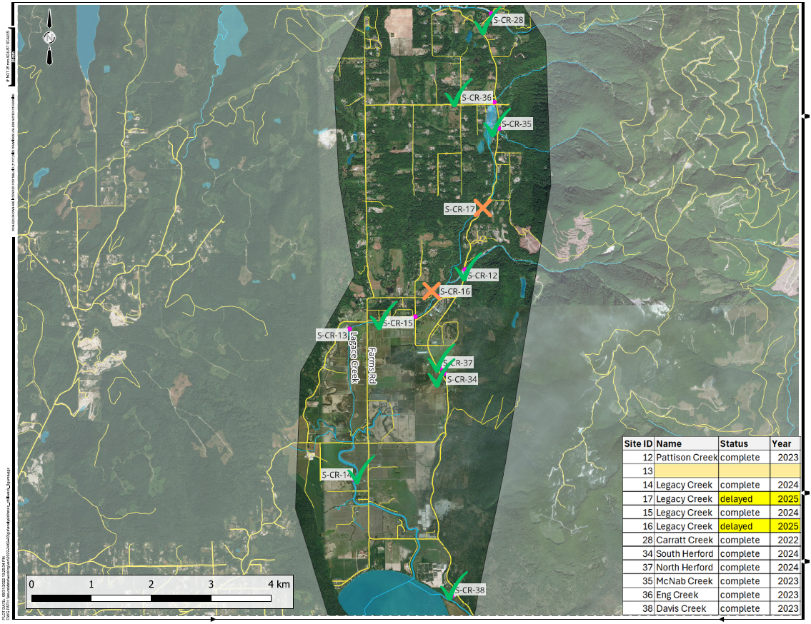
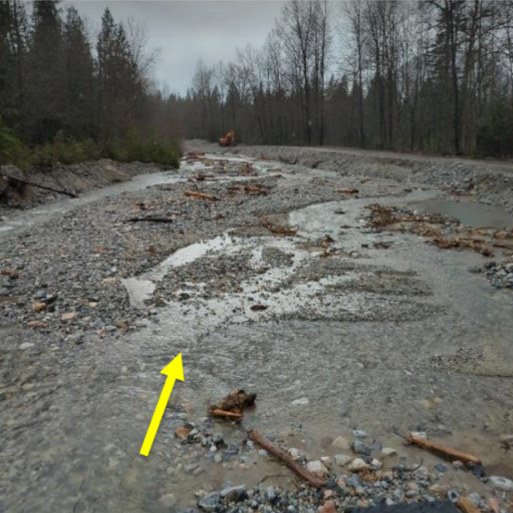
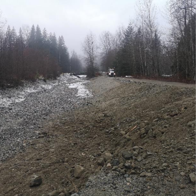
Works in the Hatzic Area include the removal of debris from waterways, culverts, bridge crossings and riverbanks. It also includes the restoration and repairing of eroded creek banks.
The Hatzic Valley is on the north side of the Fraser River Valley in British Columbia, approximately 3.5 km east of Mission. It is part of the Fraser Valley Regional District (FVRD). It includes the unincorporated communities of McConnell Creek, Hatzic Prairie and Durieu. The valley is the part of the traditional lands of the Coastal Salish peoples. It is currently home to approximately 1,300 people (FVRD, 2023).
Hatzic Valley runs from north to south, extending from the southeast point of Stave Lake. The midlands located south of Stave Lake serve as a valley drainage divide. Creeks north of the divide flow to the northwest into Stave Lake. The rest of the valley drains to the south, entering Hatzic Slough in the Hatzic Prairie lowlands, then Hatzic Lake.
Hatzic Lake in turn drains through the Fraser River dike and into the Fraser River. The Dewdney Area Improvement District (DAID) serves as Diking Authority for the Hatzic reach of the Fraser River dike. It extends from Dewdney Trunk Road and Lougheed Highway in Mission, BC to Bell Road in Dewdney, BC. This dike prevents the Fraser River from flooding the properties on the floodplain north of the river (DAID, 2023).
During the November 2021 Atmospheric River Event significant overland flooding occurred. In-stream sediment deposition affected stream reaches throughout lower Hatzic Valley. It increased the likelihood of flood related damage to various infrastructure. It also threatened residents near the watercourses.
The intention is to decrease the instream sediment load to reduce the likelihood of future flood damage for 13 sites.
Project Details
Total Budget:
$21.8 Million
Newsletter
Hatzic Valley Emergency Works Program - January 2024 [PDF, 1,561KB]
Hatzic Valley Emergency Works Program - August 2023 [PDF 1,954KB]
Projected Completion Date:
December 2023 phase 1
December 2024 Phase 2 *revised schedule proposed*
Community & Taskforce Members
- Fraser Valley Regional District
- Leq'a:mel First Nation
- Sumas First Nation
- Ministry of Environment and Climate Change Strategy
- Ministry of Forests
- Ministry of Emergency Management and Climate Readiness
- Associated Engineering
Images
Risk Evaluation
Public Health and Safety
CR-12
A channel avulsion from Patterson Creek to Lagace Creek may result in public safety risks to areas both upstream and downstream.
CR-13
Flooding will inundate access roads and driveways creating a risk to public safety.
CR-14
Road and land conditions that make travelling and accessing property dangerous. Flooding of houses.
CR-15
More scour and erosion at the south end of the bridge may result in a bridge failure with limited warning time. This creates a public safety risk.
CR-16
More bank erosion and reduced channel capacity can create a safety risk for the adjacent private property. Flooding of houses and property access is also a concern. Extra analysis is required to confirm the level of risk to public health and safety.
CR-17
Inundation of roadways and private property is expected during a high-flow event, but, this is not expected to create a significant public safety concern. Overtopping of Sylvester Road may also occur during lower rainfall events.
CR-28
A channel avulsion is possible in many locations. This would result in flows impacting adjacent properties and buildings with little to no warning. Public safety is a significant concern.
CR-34
We expect continued short-term inundation of Sylvester Road during significant rainfall events.
CR-35
There is the potential for a road washout event to impact the surrounding community. Sylvester Road is the main access road for the community.
CR-36
There is a risk of blockage at the Sylvester Road bridge due to the small hydraulic capacity and upstream sediment accumulation. This could impact the roadway and adjacent property.
CR-37
We expect continued short-term inundation of Sylvester Road during significant rainfall events. This presents a hazard to the public. The roadway would be flooded resulting in vehicles entering adjacent roadway ditches.
CR-38
There is a significant risk to residents and motorists in the event that the upstream log jam was to release on Davies Creek.
River Capacity
CR-12
Sediment deposition and bank erosion has increased the risk of a channel avulsion from Patterson Creek into Lagace Creek.
CR-13
The existing avulsion and sediment deposition creates an increased risk of flooding.
CR-14
River capacity has been reduced due to sediment deposition.
CR-15
Flow is expected to remain within the channel unless very high flows are experienced. Sediment removal at the crossing will restore the pre-November capacity.
CR-16
It does not appear that the channel capacity has been compromised; however, due to the continuous sediment deposition, it is anticipated that Creek capacity has been reduced over the past 18 years. More analysis will be required to determine the extend of deposition and its hydraulic impact to water levels in the Creek.
CR-17
Channel capacity has been reduced which creates an increased risk of flooding adjacent areas.
CR-28
The channel is full of sediment and has almost no capacity. The bridge opening is almost complete filled with sediment. Immediate action required.
CR-34
We expect South Herford Creek to temporarily inundate adjacent low-lying private property during significant rainfall events. The downstream channel has significant sediment accumulation and is compromising the hydraulic capacity of the upstream culvert under Sylvester Road.
CR-35
The channel is steep and well defined. Accumulation of sediment is not anticipated to have a significant effect on channel capacity. The capacity of the culverts is comprised due to upstream sediment.
CR-36
The channel is well defined. Accumulation of sediment is not anticipated to have a significant effect on channel capacity. The capacity of the Sylvester Road bridge is low and has been comprised due to sediment.
CR-37
We expect North Herford Creek to temporarily inundate adjacent low-lying private property during significant rainfall events.
CR-38
There is a debris jam approximately 100 m upstream of the Davies Creek culvert at Sylvester Road. The debris jam has completely filled in the channel. The capacity of the Davies Creek culvert at Sylvester Road appears insufficient. Wooden debris accumulating immediately upstream of the Sylvester Road culvert has the potential to block the culvert in a significant rainfall event.
Environmental
CR-12
A channel avulsion would result in noticeable loss of vegetation. The presence of rare species or culturally valued sites is unknown.
CR-13
Flooding will impact agricultural areas for several adjacent sites.
CR-14
Increased frequency and duration of flooding of agricultural areas is expected to result in financial losses to farmers.
CR-15
Potential for trees and vegetation along the creek edge to die if inundated for a long time. Additional bank erosion may result in more vegetation dying. This vegetation is expected to regrow. The value of the habitat is not known but is not expected to be rare.
CR-16
Constant bank erosion and sediment accumulation could potential result in noticeable loss of vegetation. The presence of rare species or culturally valued sites is unknown.
CR-17
Potential for trees and vegetation along the creek edge to die if inundated for a long time. Additional bank erosion may result in more vegetation dying. This vegetation is expected to regrow. The value of the habitat is not known but is not expected to be rare.
CR-28
Some impact to vegetation is anticipated but is expected to re-establish over time. The presence of rare vegetation or culturally significant sites is unknown.
CR-34
Hydraulic issues have been present for some time and thus expect low environmental risk.
CR-35
We expect habitat degradation within Allan Lake due to the development of the alluvial fan.
CR-36
We expect habitat degradation within Allan Lake due to the development of the alluvial fan.
CR-37
Hydraulic issues have been present for some time and thus expect low environmental risk.
CR-38
Upstream channel has been scoured to bedrock. In the event the log jam was to release there could be loss of trees and vegetation within Davies Creek for approximately 100 m upstream of Sylvester Road.
Infrastructure
CR-12
A channel avulsion may block Lagace Creek and result in flooding of upstream areas. A channel avulsion is expected to mobilize more sediment and debris which would also impact downstream areas of Lagace Creek. Private property would be at risk both upstream and downstream.
CR-13
Flooding may impact adjacent buildings, agricultural equipment and stockpiled materials.
CR-14
Residential and agricultural structures at increased risk of flooding.
CR-15
More sediment deposition and/or scour increase the vulnerability of the bridge structure which may result in loss of the bridge.
CR-16
We are not aware that the existing private property near the site has been impacted by high-flow events. Additional sediment deposition and reduced channel capacity would have a negative impact to this area. Private property would be at risk of flooding.
CR-17
Potential impacts to nearby private buildings and Sylvester Road.
CR-28
Loss of the Carratt Creek bridge would prevent emergency evacuation of residents and delay emergency responders.
CR-34
We expect minor damage to the shoulders of Sylvester Road during significant rainfall events. There is a possibility that a significant rainfall event could wash out the roadway.
CR-35
We expect more damage to the shoulders of Sylvester Road during significant rainfall events due to inadequate capacity of the existing culverts. There is a possibility that a significant rainfall event could wash out the roadway.
CR-36
We expect low risks to the Hartley Road bridge due to the large hydraulic capacity. We expect medium risks to the Sylvester Road bridge due to the low hydraulic capacity.
CR-37
We expect minor damage to the shoulders of Sylvester Road during significant rainfall events. There is a possibility that a significant rainfall event could wash out the roadway.
CR-38
There is a significant risk to Sylvester Road and downstream properties in the event that the upstream log jam was to release on Davies Creek.
Contact information
sec.info.epd@gov.bc.ca
Subscribe
Enter your email address to subscribe to updates of this page.


